Contents
The Annapurna Circuit with Tilicho Lake combines two of Nepal's most spectacular trekking routes into one comprehensive mountain journey.
This 15-day itinerary reaches the world's highest lake at 4,949 meters before crossing Thorong La Pass at 5,416 meters. The route covers approximately 200 kilometers through diverse landscapes, from subtropical valleys to high-altitude desert plateaus.
The standard Annapurna Circuit trek bypasses Tilicho Lake, missing one of the Himalayas' most dramatic natural features. Adding Tilicho Lake extends the trek by three days and increases overall difficulty through higher altitude exposure and additional climbing. The detour demands strong fitness and proper acclimatization but rewards trekkers with pristine turquoise waters surrounded by towering peaks.
This guide provides the complete day-by-day itinerary, altitude profile, difficulty assessment, cost breakdown, and preparation requirements for the Annapurna Circuit with Tilicho Lake trek. Realistic planning and thorough preparation determine success on this demanding route.
Overview of Annapurna Circuit with Tilicho Lake Trek
The Annapurna Circuit with Tilicho Lake trek starts in Kathmandu and follows the classic circuit route through Besisahar, Chame, and Manang before detouring north to Tilicho Lake. After visiting the lake, the route rejoins the main circuit at Yak Kharka, continues over Thorong La Pass, and descends through Muktinath to Tatopani. The journey concludes with a return to Pokhara and Kathmandu.
Total trekking distance exceeds 200 kilometers with cumulative elevation gain surpassing 8,000 meters. Daily walking time ranges from five to nine hours depending on the section. The highest sleeping altitude reaches 4,450 meters at Thorong Phedi the night before crossing Thorong La Pass.
The trek passes through four distinct climate zones: subtropical forests below 2,000 meters, temperate forests from 2,000-3,000 meters, alpine meadows from 3,000-4,000 meters, and high-altitude desert above 4,000 meters. Cultural diversity matches geographical variation, with Hindu communities in lower regions transitioning to Tibetan Buddhist villages at higher elevations.
Route Highlights
- Tilicho Lake at 4,949 meters, one of the world's highest lakes
- Thorong La Pass at 5,416 meters, the trek's maximum elevation point
- Ancient Tibetan Buddhist monasteries in Manang and Muktinath
- Dramatic landscape transitions from green valleys to barren highlands
- Traditional Gurung, Manangi, and Thakali villages
- Natural hot springs at Tatopani for post-trek recovery
- Panoramic mountain views including Annapurna range, Dhaulagiri, and Manaslu
- Kali Gandaki Gorge, the world's deepest gorge
- Muktinath temple, sacred pilgrimage site for Hindus and Buddhists
Detailed 15-Day Itinerary
Day 1: Kathmandu to Besisahar (760m)
Day 2: Besisahar to Chame (2,610m)
Day 3: Chame to Pisang (3,300m)
Day 4: Pisang to Manang (3,500m)
Day 5: Acclimatization at Manang (3,540m)
Day 6: Manang to Siri Kharka (4,060m)
Day 7: Siri Kharka to Tilicho Base Camp (4,140m)
Day 8: TBC to Tilicho Lake (4,949m) and back to Siri Kharka (4,060m)
Day 9: Siri Kharka to Yak Kharka (4,040m)
Day 10: Yak Kharka to Thorong Phedi (4,450m)
Day 11: Thorong Phedi to Thorong La Pass (5,416m) to Muktinath (3,710m)
Day 12: Muktinath to Tatopani (1,300m)
Day 13: Tatopani to Beni (899m) to Pokhara (850m)
Day 14: Excursion in Pokhara (850m)
Day 15: Pokhara to Kathmandu (827m)
Day 1-2: Journey to Chame (2,610m)
The trek begins with a scenic 6-7 hour drive from Kathmandu to Besisahar following the Prithvi Highway through terraced farmland and riverside villages. Road conditions vary seasonally, monsoon landslides occasionally cause delays.
Besisahar serves as the official circuit starting point with basic tea houses and permit checkpoints.
Day two combines vehicle transport and trekking. A rough mountain road carries trekkers from Besisahar through Bhulbhule and Jagat to Dharapani. The unpaved track clings to steep hillsides with minimal barriers. From Dharapani, foot trails begin following the Marsyangdi River through pine and fir forests. Chame sits at 2,610 meters as Manang district headquarters. Apple orchards surround the village. Mountain views include Annapurna II (7,937m) and Lamjung Himal (6,983m). Tea houses offer improved facilities with hot showers and bakeries.
Day 3-4: Chame to Manang (3,500m)
The trail climbs steadily through changing vegetation zones, passing through Telekhu and Bratang before reaching Pisang. Dense forests cover lower sections. A dramatic gorge section features vertical cliff faces on both sides. Prayer wheels and chortens appear frequently, indicating Tibetan Buddhist cultural influence.
At Lower Pisang, the route splits. Most trekkers choose Upper Pisang for superior mountain views and cultural interest. The upper village features traditional stone houses with flat roofs and an ancient monastery. Altitude effects begin appearing—breathing feels slightly heavier during exertion.
Two route options exist between Pisang and Manang. The upper route climbs to Ghyaru (3,670m) and Ngawal (3,660m), providing spectacular scenery despite demanding more effort. Ancient villages cling to hillsides with dramatic Annapurna views. The landscape resembles Tibetan plateau terrain with barren hillsides contrasting white peaks.
Manang serves as the primary acclimatization stop. This substantial village offers extensive facilities including lodges, restaurants, shops, medical clinic, and internet cafes. The Himalayan Rescue Association operates a health post providing daily altitude sickness lectures. Surrounding peaks include Gangapurna (7,455m), Annapurna III (7,555m), and Tilicho Peak (7,134m).
Day 5: Critical Acclimatization at Manang
Rest days prove essential for successful high-altitude trekking. Manang's acclimatization day allows the body to adapt before climbing higher. The day involves short hikes to higher elevation followed by return to Manang, triggering physiological adaptations.
Ice Lake (4,600m) provides the best acclimatization hike. This challenging 4-5 hour round trip climbs 1,100 meters through juniper forest into alpine terrain. Alternative options include Gangapurna Lake (3,540m) for gentle exercise, Praken Gompa (3,800m) for cultural interest, or Khangsar Village (3,750m) through arid landscape.
The Himalayan Rescue Association's afternoon lecture (3:00 PM) covers altitude sickness symptoms, prevention, and emergency responses. Attendance strongly benefits all trekkers planning high passes.
Day 6-8: Tilicho Lake Detour
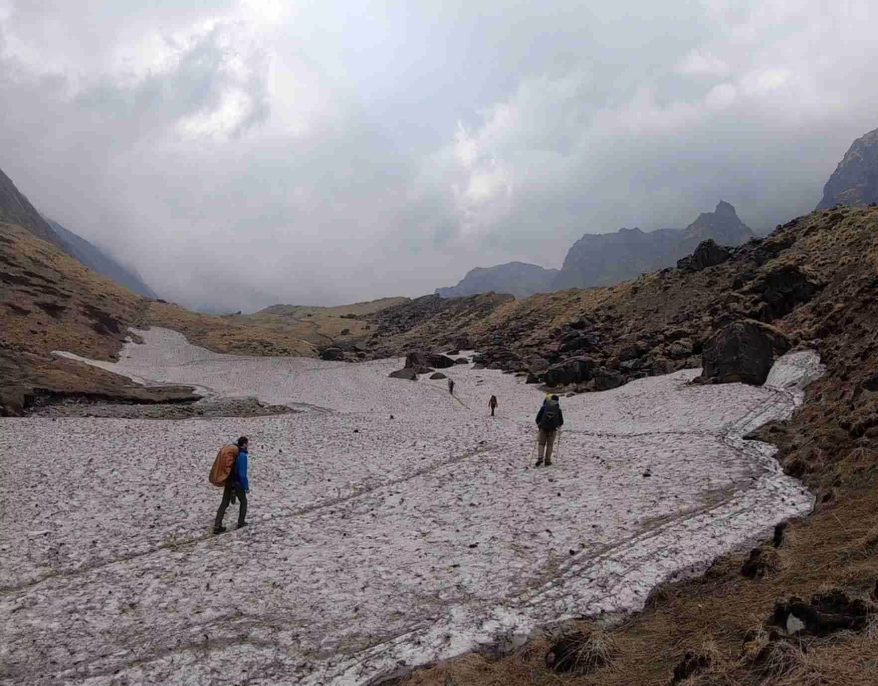
Day six begins the Tilicho detour. The trail leaves Manang heading northwest toward Khangsar rather than continuing the main circuit route. The path crosses barren valley floor with minimal vegetation. Khangsar marks the last permanent settlement before Tilicho Base Camp. Beyond Khangsar, steady climbing begins through rocky terrain. Loose scree demands careful footing.
Siri Kharka sits at 4,060 meters on flat grazing grounds. Accommodation remains very basic—simple rooms, outdoor squat toilets, no showers. Cold water comes from taps or buckets. Wood stoves provide dining hall warmth. Altitude effects become noticeable. Breathing requires more effort. Sleep quality may decrease.
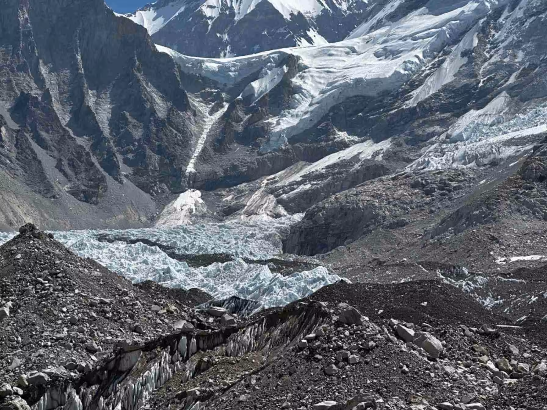
Day seven covers short distance to Tilicho Base Camp, allowing afternoon rest. The trail crosses landslide zones requiring careful navigation. Rockfall occurs frequently during afternoon hours when sun warms slopes. Tilicho Base Camp sits in a harsh, rocky basin at 4,140 meters. Facilities match the remote location—minimal bedding, unheated bathrooms, melted snow for water.
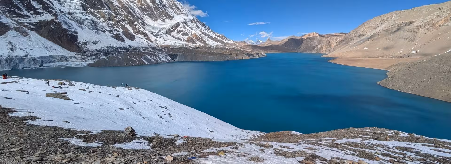
Day eight represents the trek's highlight. Pre-dawn start (4:00-5:00 AM) reaches Tilicho Lake at sunrise. The climb covers 809 vertical meters over four kilometers. The trail traverses steep hillsides across loose scree. Fixed ropes assist exposed sections. Altitude makes each step challenging. Rest stops occur every 10-15 minutes.
Tilicho Lake sits at 4,949 meters surrounded by 7,000-meter peaks. The massive turquoise lake measures approximately 4 kilometers long. Glacial flour creates the distinctive color. Ice often covers portions of the surface. Extreme altitude creates noticeable effects—breathing requires conscious effort, headaches may appear. Time at the lake stays limited to 1-2 hours maximum. After descent to base camp, the trek continues to Siri Kharka. Total day involves 8-10 hours with significant altitude exposure.
Day 9-11: Thorong La Pass Crossing
Day nine rejoins the main circuit, retracing to Khangsar then heading east toward Thorong La. The route involves minimal elevation change, allowing recovery. The trail crosses barren terrain with rocky ground and dusty paths. Yak Kharka sits at 4,040 meters in a wide valley. Basic tea houses provide accommodation.
Day ten reaches Thorong Phedi at 4,450 meters. The short trek follows a gradual upward grade. Stone steps appear at steeper sections. Thorong Phedi sits in a confined valley directly below the pass. Very basic lodges cluster in the narrow space. The afternoon focuses on rest, hydration, and preparation for the 3:00-4:00 AM start.
Day eleven crosses Thorong La Pass, the trek's most challenging section. The climb covers 966 vertical meters through countless switchbacks.
At 5,000+ meters, oxygen drops to 50% of sea level. Each step requires deliberate effort. Rest breaks occur every 10-15 steps. The climb takes four to five hours.
Thorong La Pass sits at 5,416 meters marked by prayer flags. Mountain panoramas include Dhaulagiri (8,167m) and Annapurna I (8,091m). Temperature ranges from -10°C to -20°C with severe wind chill. The descent drops 1,706 meters to Muktinath through steep, rocky terrain. Knees absorb tremendous impact. Total time ranges 8-10 hours.
Muktinath offers comfortable lodges after a grueling pass day. This sacred pilgrimage site features 108 water spouts and an eternal flame. Hot showers and varied meals provide welcome relief.
Day 12-15: Return Journey
Day twelve descends by jeep from Muktinath to Tatopani, passing through Kagbeni and Jomsom. The road follows the Kali Gandaki valley—the world's deepest gorge carved between Dhaulagiri and Annapurna I. Tatopani sits at 1,300 meters featuring natural hot springs for muscle recovery.
Day thirteen continues by vehicle to Pokhara through rough mountain roads. Pokhara sits at 850 meters on Phewa Lake shores offering full urban amenities.
Day fourteen allows rest and exploration. Sarangkot provides sunrise views. Phewa Lake offers boating. The World Peace Pagoda, Davis Falls, and International Mountain Museum present sightseeing options.
Day fifteen returns to Kathmandu by tourist bus (6-7 hours) or domestic flight (25 minutes), completing the 15-day journey.
Annapurna Circuit with Tilicho Lake Route Map
The trek forms a counterclockwise loop around the Annapurna massif with a northern detour to Tilicho Lake. The route begins and ends in Kathmandu with the actual trekking circuit running from Besisahar through Manang, Tilicho Lake, Thorong La Pass, and Muktinath before returning via road to Pokhara.
Route Progression:
Kathmandu (1,400m) → Besisahar (760m) → Chame (2,610m) → Pisang (3,300m) → Manang (3,500m) → Siri Kharka (4,060m) → Tilicho Base Camp (4,140m) → Tilicho Lake (4,949m) → Yak Kharka (4,040m) → Thorong Phedi (4,450m) → Thorong La Pass (5,416m) → Muktinath (3,710m) → Tatopani (1,300m) → Pokhara (850m) → Kathmandu (1,400m)
Annapurna Circuit with Tilicho Lake Trek Cost
Total trek cost ranges from $1,200 to $2,500 per person depending on service level, group size, and included features. Costs break down into permits, guide and porter fees, accommodation, meals, transportation, and miscellaneous expenses.
Cost Components
Permits:
- ACAP (Annapurna Conservation Area Permit): $30 per person
- TIMS Card (Trekkers' Information Management System): $20 per person
- Total Permits: $50 per person
Guide Services:
- Budget guide: $30-35 per day
- Standard guide: $40-45 per day
- Premium guide: $50-60 per day
- Total Guide Cost (15 days): $450-900
Porter Services:
- Budget porter: $25-30 per day
- Standard porter: $30-35 per day
- Total Porter Cost (15 days): $375-525
Accommodation:
- Budget tea houses: $3-5 per night
- Standard tea houses: $5-10 per night
- Better lodges: $10-15 per night
- Total Accommodation (14 nights): $42-210
Meals:
- Budget: $15-20 per day
- Standard: $25-30 per day
- Varied menu: $30-40 per day
- Total Meals (15 days): $225-600
Transportation:
- Kathmandu-Besisahar-Kathmandu: $100-150
- Chame-area jeep: $30-50
- Muktinath-Tatopani jeep: $40-60
- Pokhara-Kathmandu bus/flight: $10-130
- Total Transportation: $180-390
Miscellaneous:
- Hot showers, WiFi, charging: $50-100
- Snacks and drinks: $50-100
- Tips for guides/porters: $100-200
- Total Miscellaneous: $200-400
Best Season for Annapurna Circuit with Tilicho Lake
Spring Season (March-May)
Spring provides excellent conditions for the Annapurna Circuit with Tilicho Lake. Clear weather dominates most days with moderate temperatures and good visibility.
March: Early spring conditions vary. Lower elevations warm up with temperatures 10-20°C. High passes remain cold (-15°C at night). Snow may block Tilicho Lake access early in the month. Rhododendrons begin blooming in lower forests.
April: Peak spring conditions develop. Temperature ranges from 15-25°C in valleys, -5°C to 5°C at high camps. Rhododendron forests display spectacular blooms. Clear skies provide excellent mountain views. Tilicho Lake becomes reliably accessible. Increasing crowds appear on popular routes.
May: Late spring brings warmer temperatures but afternoon clouds develop more frequently. Valley temperatures reach 20-28°C. High passes remain cold at night. Pre-monsoon weather creates afternoon thunderstorms in lower regions. Upper areas stay dry. Tourist numbers peak.
Trail Conditions: Dry and well-maintained throughout spring. Stream crossings present minimal difficulty. Snow clears from passes by late March or early April.
Autumn Season (September-November)
Autumn ranks as the most popular trekking season due to stable weather patterns and crystal-clear visibility.
September: Post-monsoon conditions transition. Early September may see lingering rain in lower regions. Mid-to-late September brings improving weather. Trails remain muddy from monsoon. The vegetation looks lush and green. Temperatures range from 15-25°C in valleys, -5°C to 5°C at passes.
October: Prime trekking month with ideal conditions. Clear skies dominate. Temperatures moderate throughout. Visibility reaches maximum clarity. Mountain views appear sharp and detailed. This represents peak season with maximum crowds. Lodges fill quickly; advance booking helps.
November: Late autumn continues excellent weather with decreasing crowds. Temperatures drop noticeably. Valley temperatures range 10-20°C. High passes experience -10°C to -20°C at night. Clear weather persists. Late November brings early winter conditions to highest elevations.
Trail Conditions: Excellent throughout autumn. Dry trails, low stream levels, and stable weather create optimal trekking. Dust accumulates on heavily trafficked sections.
Winter Season (December-February)
Winter trekking presents serious challenges but rewards experienced adventurers with solitude and clarity.
Conditions: Extreme cold dominates. High passes drop to -25°C to -30°C. Thorong Phedi experiences -15°C to -20°C. Heavy snowfall affects areas above 4,000m. Thorong La Pass closes occasionally. Tilicho Lake freezes completely and may be inaccessible. Days shorten significantly—limited trekking hours. Most tea houses close; only a few lodges remain open.
Requirements: Expedition-grade equipment necessary. Four-season sleeping bags rated -25°C minimum. Down suits or heavy insulation for pass crossings. Winter trekking demands serious mountain experience.
Benefits: Crystal-clear visibility. Complete solitude on trails. Sharp mountain views. Unique winter landscape photography.
Monsoon Season (June-August)
Monsoon brings heavy rainfall to lower elevations while upper areas receive less precipitation.
Conditions: Heavy rain below 3,000m creates muddy, slippery trails. Landslides block routes occasionally. Leeches appear in forests. Cloud cover obscures mountain views for extended periods. Areas above 4,000m stay drier as moisture falls at lower elevations. Temperature ranges 15-25°C in valleys.
Challenges: Limited visibility, uncertain conditions, and trail difficulties make monsoon least suitable season. However, empty trails and green landscapes appeal to adventurous trekkers.
Tilicho Lake Access: Lake access improves during monsoon as snow melts. However, trail conditions and landslide risks increase dangers.
Altitude Profile and Acclimatization Strategy
The Annapurna Circuit with Tilicho Lake reaches extreme altitudes requiring careful acclimatization planning. The route design includes strategic rest days and gradual elevation gain to minimize altitude sickness risk.
Altitude Progression
Days 1-4 (760m to 3,500m): Gradual ascent over four days allows initial acclimatization. Daily elevation gains average 600-700 meters. This measured approach helps the body begin adaptation.
Day 5 (Manang 3,540m): Critical acclimatization rest day. Short hikes to higher elevation (4,000-4,600m) followed by return to Manang trigger adaptation while maintaining safe sleeping altitude. Following proper Annapurna Circuit acclimatization protocols during this rest day significantly reduces altitude sickness risk for the days ahead.
Days 6-8 (3,540m to 4,949m): Rapid ascent to Tilicho Lake. The detour reaches 4,949m—the trek's highest point besides the pass. Three days at 4,000+ meters provides intensive altitude exposure.
Day 9-10 (4,060m to 4,450m): Continued high-altitude exposure prepares for Thorong La crossing.
Day 11 (4,450m to 5,416m to 3,710m): Thorong La day reaches maximum 5,416m but descends to 3,710m for sleeping. "Climb high, sleep low" principle optimally applied.
Days 12-15: Rapid descent to lower elevations allows recovery.
Acclimatization Recommendations
Hydration: Drink 4-5 liters daily above 3,000m. Dehydration worsens altitude symptoms significantly. Monitor urine color—pale yellow indicates adequate hydration.
Ascent Rate: Follow "climb high, sleep low" principle. Daily sleeping elevation gain should not exceed 500 meters above 3,000m. Rest days every 1,000m elevation gain optimize adaptation.
Diamox Consideration: Acetazolamide (125-250mg twice daily) accelerates acclimatization for some trekkers. Consult physician before use. Start medication 1-2 days before ascent.
Symptom Monitoring: Watch for headache, nausea, dizziness, unusual fatigue, and sleep disturbance. Mild symptoms usually resolve with rest and hydration. Moderate symptoms require halting ascent. Severe symptoms demand immediate descent.
Avoid Alcohol: Alcohol causes dehydration and impairs acclimatization. Avoid consumption above 3,000m.
Pace Control: Walk slowly at conversation pace. Rapid hiking increases altitude sickness risk. Rest breaks every 30-40 minutes maintain sustainable effort.
Physical Fitness and Training Requirements
The Annapurna Circuit with Tilicho Lake demands excellent physical conditioning and mental preparation. Daily trekking ranges 5-10 hours over varied terrain while carrying a daypack at altitude.
Cardiovascular Endurance
Strong aerobic fitness allows sustained effort at altitude where oxygen levels drop significantly. Training should focus on endurance activities 4-5 times weekly for 3-4 months pre-trek.
Effective Training:
- Running or jogging: 45-60 minutes at moderate pace
- Cycling: 60-90 minutes on varied terrain
- Swimming: 45-60 minutes continuous
- Stair climbing: 30-45 minutes with weighted pack
- Hiking: 4-6 hour hikes on local trails with elevation gain
Gradually increase training intensity and duration. Include interval training simulating varied mountain pace. Long weekend hikes (6-8 hours) build mental and physical endurance.
Leg Strength and Endurance
Quadriceps, hamstrings, calves, and stabilizing muscles all face sustained workload during long trekking days. Descents particularly stress knees and ankles.
Strengthening Exercises:
- Squats and lunges (3 sets of 15-20 repetitions)
- Step-ups on elevated platform with weighted pack
- Calf raises (3 sets of 20 repetitions)
- Wall sits (3 sets of 60 seconds)
- Hill repeats carrying weight
Practice hiking with 7-10kg backpack to simulate trekking load. This reveals pack fit issues and builds specific strength for load carrying.
Core Stability
Strong core muscles improve balance on uneven trails and reduce back strain from pack weight. Include core exercises in regular training.
Core Training:
- Planks (front and side): 3 sets of 60 seconds
- Mountain climbers: 3 sets of 20 repetitions
- Russian twists: 3 sets of 20 repetitions
- Bird dogs: 3 sets of 15 each side
Mental Preparation
Long trekking days test patience, motivation, and mental resilience. Cold mornings, altitude discomfort, and basic conditions challenge psychological strength. Previous multi-day trekking experience builds mental toughness.
Age and Medical Considerations
The trek suits ages 15+ with appropriate fitness and maturity. Younger trekkers require guardian supervision and careful health monitoring. No upper age limit exists if fitness and health permit. Trekkers in their 60s and 70s complete the circuit successfully with proper preparation.
Pre-existing medical conditions require physician consultation. Heart disease, lung conditions, previous severe altitude sickness, or significant joint problems warrant careful evaluation and medical clearance before attempting high-altitude trekking.
Essential Packing List
Proper equipment ensures comfort, safety, and enjoyment across widely varied conditions. The list balances essential items against weight considerations.
Clothing Layers
Base Layers:
- Thermal tops: 2-3 sets (synthetic or merino wool)
- Thermal bottoms: 2 sets (synthetic or merino wool)
- Underwear: 5-6 pairs (synthetic or merino, no cotton)
- Sports bras: 3-4 (for women)
Mid Layers:
- Fleece jacket: 1 lightweight fleece
- Insulated jacket: 1 synthetic or light down
- Down jacket: 1 expedition-weight (800+ fill power)
- Trekking shirts: 3-4 quick-dry shirts
- Trekking pants: 2 pairs convertible or standard
- Thermal pants: 1 pair for sleeping at altitude
Outer Layers:
- Waterproof jacket: 1 hardshell with hood
- Waterproof pants: 1 pair hardshell
- Windproof jacket: Optional softshell alternative
Accessories:
- Warm beanie: 1 fleece or wool
- Sun hat: 1 wide-brimmed
- Balaclava: 1 for face protection
- Gloves: Thin liner gloves plus insulated gloves/mittens
- Neck gaiter or buff: 2 for versatility
Footwear
- Trekking boots: 1 pair broken-in with good ankle support
- Camp shoes: 1 pair lightweight sandals or slip-ons
- Trekking socks: 5-6 pairs wool or synthetic blend
- Sock liners: 2-3 pairs thin synthetic (optional)
- Gaiters: 1 pair for snow or mud protection
Technical Equipment
- Backpack: 50-65 liter capacity with rain cover
- Daypack: 20-30 liter for Tilicho Lake day hike
- Trekking poles: 1 pair adjustable with shock absorption
- Sleeping bag: -15°C to -20°C comfort rating
- Sleeping bag liner: Adds warmth and hygiene
- Headlamp: With spare batteries and red light mode
- Water bottles: 2x 1-liter wide-mouth bottles
- Hydration bladder: 2-3 liter capacity (optional)
- Water purification: Tablets or filter
- Sunglasses: Category 4 UV protection with side shields
- Stuff sacks: Waterproof bags for organization
- Dry bags: For electronics and important documents
- Compression sacks: For clothing and sleeping bag
First Aid and Medications
- Personal prescriptions: Full trek duration plus extra
- Altitude medication: Diamox if prescribed
- Pain relievers: Ibuprofen and paracetamol
- Antibiotics: Ciprofloxacin or azithromycin (prescription)
- Anti-diarrheal: Loperamide
- Rehydration salts: Electrolyte packets
- Blister treatment: Moleskin, athletic tape, bandages
- Antiseptic: Small tube or packets
- Antibiotic ointment: For cuts and scrapes
- Altitude sickness assessment: Pulse oximeter (optional)
- Bandages: Various sizes
- Medical tape: 1-2 rolls
- Scissors and tweezers
- Thermometer
- Hand sanitizer: Alcohol-based
Toiletries and Personal Care
- Toothbrush and toothpaste
- Biodegradable soap
- Shampoo (small bottle)
- Quick-dry towel
- Wet wipes: Multiple packs
- Toilet paper: 1-2 rolls
- Sunscreen: SPF 50+ (2-3 tubes)
- Lip balm: SPF 30+ (2-3 sticks)
- Moisturizer: For dry conditions
- Feminine hygiene products: As needed
- Nail clippers
- Small mirror
Electronics and Accessories
- Mobile phone and charger
- Power bank: 20,000+ mAh capacity
- Camera with spare batteries and memory cards
- Adapter plugs: Nepal uses Type C, D, and M
- Headphones or earplugs
- E-reader or book
- Solar charger: Optional for extended charging
Documents and Money
- Passport with Nepal visa
- Extra passport photos: 4-6 for permits
- Travel insurance documents: Including evacuation coverage
- ACAP and TIMS permits: Obtained before trek
- Emergency contact information
- Credit card: Backup payment
- Cash: Nepali rupees and USD for emergencies
- Money belt or neck wallet: For document security
Optional Items
- Journal and pen
- Playing cards
- Small padlock: For duffel bag security
- Bandana or handkerchief
- Sewing kit: For repairs
- Duct tape: Wrapped around trekking pole
- Zip-lock bags: Various sizes for organization
- Garbage bags: For waste management
- Whistle: For emergency signaling
Permits Required
Annapurna Conservation Area Permit (ACAP)
Cost: NPR 3,000 (~$30 USD) for foreign nationals
Cost: NPR 1,000 (~$10 USD) for SAARC citizens
Processing: Available in Kathmandu or Pokhara
Requirements: Passport and 2 passport photos
ACAP fees fund conservation programs, community development, and trail maintenance throughout the Annapurna Conservation Area. The permit covers all routes within the protected area.
Trekkers' Information Management System (TIMS) Card
Cost: NPR 2,000 (~$20 USD) for independent trekkers
Cost: NPR 1,000 (~$10 USD) for organized groups
Processing: Through registered trekking agencies
Requirements: Passport and agency verification
TIMS creates a database for trekker safety monitoring and emergency response. The system helps locate missing trekkers and coordinate rescue operations.
Permit Procurement: Trekking companies typically arrange permits as part of package services. Independent trekkers obtain permits at tourism offices in Kathmandu (Nepal Tourism Board) or Pokhara before starting the trek. Complete details about documentation requirements and processing procedures are available in our comprehensive Annapurna Circuit trek permits guide.
Accommodation Standards on Annapurna Circuit with Tilicho Lake
Accommodation quality drops steadily as elevation increases along the Annapurna Circuit with Tilicho Lake. Lower villages below 3,000 meters like Besisahar, Chame, and Pisang offer the best facilities. Tea houses provide private twin rooms with decent mattresses and shared bathrooms with Western-style toilets.
Hot water comes from solar panels or wood heaters for $2-5 per shower. Electricity allows device charging for $1-3 per item. WiFi exists in many lodges for $2-5 daily, though speeds vary. Dining halls serve varied menus including dal bhat, noodles, pizza, and pasta.
Mid-elevation lodges from 3,000-4,000 meters maintain basic but adequate standards. Rooms have simple beds with thin mattresses.
Electricity grows sporadic with higher charging fees ($3-5). WiFi becomes unreliable or disappears. Menus focus on high-calorie basics like dal bhat, noodles, and soup. Wood or yak dung stoves heat dining halls where trekkers gather during cold evenings. Night temperatures drop significantly despite stoves, making sleeping bags essential.
High-altitude accommodation above 4,000 meters at Siri Kharka, Tilicho Base Camp, and Thorong Phedi offers only basic shelter. Rooms contain simple beds with minimal bedding. Trekkers need sleeping bags rated to -15°C or colder. Bathrooms are unheated outdoor squat toilets. No hot water exists. Washing facilities provide only cold water from taps or melted snow. Electricity remains minimal, some lodges offer solar lighting for a few hours nightly.
Device charging costs $5-10 and often fails. WiFi does not exist. Meals simplify to dal bhat, noodles, and soup. Dining halls with wood or yak dung stoves provide the only warmth when temperatures drop to -15°C or below. Despite harsh conditions, these lodges provide essential shelter, hot food, and protection from extreme weather.
Difficulty Level Assessment
The Annapurna Circuit with Tilicho Lake rates as challenging to strenuous difficulty. Multiple factors combine to create significant physical and mental demands.
Physical Challenges
- Daily Distance: 10-20 kilometers depending on section
- Walking Time: 5-10 hours daily over varied terrain
- Elevation Gain: 8,000+ meters cumulative ascent
- Pack Weight: 7-12 kg daypack (less if using porter)
- Duration: 15 consecutive trekking days
Altitude Challenges
- Maximum Altitude: 5,416m (Thorong La Pass)
- Highest Sleep: 4,450m (Thorong Phedi)
- Extended High Altitude: 7 days above 4,000m
- Oxygen Levels: Drop to 50% at highest points
- Acclimatization Required: Critical for safety
Technical Difficulty
The trail requires no technical mountaineering skills. No rope work, ice axe use, or rock scrambling occurs on standard route. However, several factors create difficulty:
- Narrow exposed sections require careful attention
- Landslide zones near Tilicho demand caution
- Stream crossings on simple bridges
- Steep descents stress knees and ankles
- Altitude-induced disorientation affects judgment
Comparison to Other Nepal Treks
- Easier Than: Everest Base Camp with Three Passes, Kanchenjunga Circuit, Dolpo Circuit
- Harder Than: Annapurna Base Camp, Langtang Valley, Everest Base Camp standard route
- Similar To: Manaslu Circuit, Annapurna Circuit without Tilicho
Who Should Attempt This Trek
Well-Suited Candidates:
- Previous high-altitude trekking experience (above 4,000m)
- Excellent cardiovascular fitness and leg strength
- Ability to walk 6-8 hours daily for consecutive days
- Mental resilience for basic conditions and challenges
- Serious commitment to 3-month training program
- Flexibility for weather-related itinerary changes
Poorly-Suited Candidates:
- First-time high-altitude trekkers (consider shorter routes first)
- Limited pre-trek training time (minimum 3 months needed)
- Inflexible schedules unable to accommodate extra days
- Medical conditions affecting altitude tolerance
- Low tolerance for basic facilities and discomfort
Safety Considerations and Risk Management
Altitude Illness
Acute Mountain Sickness (AMS) affects 40-50% of trekkers above 4,000m. Symptoms include headache, nausea, dizziness, fatigue, and poor sleep. Mild AMS responds to rest, hydration, and slow ascent. Moderate AMS requires halting ascent until symptoms resolve.
High Altitude Cerebral Edema (HACE) represents life-threatening condition with severe headache, confusion, loss of coordination, and altered consciousness. Immediate descent is mandatory.
High Altitude Pulmonary Edema (HAPE) causes severe shortness of breath at rest, chest tightness, cough with pink frothy sputum, and extreme fatigue. Immediate descent and evacuation are necessary.
Guide monitoring, proper acclimatization, and quick response prevent most serious outcomes. Trekkers must report all symptoms immediately rather than dismissing or hiding them.
Weather Hazards
Sudden weather changes create multiple dangers at high altitude. Temperature drops, heavy snowfall, and strong winds occur with minimal warning. Proper clothing layers and weather monitoring reduce risks.
Afternoon thunderstorms develop during shoulder seasons. Lightning danger increases above treeline. Avoid ridge walking during storms.
Trail Hazards
Landslide zones near Tilicho Lake require careful passage. Cross quickly during early morning when slopes remain frozen. Avoid afternoon crossings when solar heating destabilizes slopes.
Suspension bridges feel intimidating but pose minimal danger when crossed carefully, one person at a time. Follow posted weight limits.
Stream crossings increase difficulty during monsoon high-water periods. Some crossings require careful boulder-hopping or log bridges.
Medical Evacuation
Helicopter evacuation from remote locations costs $4,000-8,000 depending on pickup altitude and weather. Insurance covering evacuation up to 6,000m is mandatory. Weather must allow helicopter flight—delays occur during storms.
Kathmandu hospitals provide good medical care. Serious conditions may require evacuation to Thailand or home country for optimal treatment.
Insurance Requirements
Comprehensive travel insurance must cover:
- Trekking up to 6,000m elevation
- Helicopter evacuation from remote areas
- Medical treatment in Nepal
- Emergency repatriation
- Trip cancellation and interruption
Standard travel insurance excludes high-altitude activities. Specialized adventure travel insurance provides necessary coverage. Verify policy details including specific elevation limits and exclusions.
Why Choose Mountain Routes
Professional guide services significantly improve safety, success rates, and overall experience on challenging treks like the Annapurna Circuit with Tilicho Lake.
Government-Licensed Guides
All Mountain Routes guides hold official licenses requiring comprehensive training in mountain safety, first aid, altitude illness, weather assessment, and rescue coordination. Years of guiding experience supplement formal training.
Guides provide:
- Continuous health monitoring and altitude sickness detection
- Route navigation and safety assessment
- Cultural and natural interpretation
- Emergency response and evacuation coordination
- Language assistance and logistics management
Safety Support Systems
Mountain Routes maintains emergency protocols and communication networks for rapid response. Guides carry satellite phones and first aid equipment. Helicopter evacuation coordination begins immediately when serious illness or injury occurs.
The company verifies comprehensive insurance coverage before trek departure, ensuring trekkers carry appropriate evacuation coverage.
Flexible Itinerary Management
Weather changes, altitude symptoms, or unexpected events may require itinerary modifications. Mountain Routes accommodates necessary adjustments while maintaining safety priorities. Extra rest days can be added if altitude symptoms appear. Routes can be modified if conditions deteriorate.
Porter Services
Porter support significantly reduces physical strain by carrying main luggage (up to 20kg) between lodges. Trekkers carry only daypacks with essential items, reducing fatigue and improving enjoyment. Porters receive fair wages, appropriate gear, and insurance coverage meeting ethical tourism standards.
Frequently Asked Questions
How difficult is the Annapurna Circuit with Tilicho Lake trek?
The trek rates as challenging to strenuous difficulty due to long duration (15 days), high altitude (5,416m maximum), extended periods above 4,000m, and significant daily distances. Previous high-altitude trekking experience helps significantly. Three months of serious physical training prepares the body for sustained effort at altitude. The trek demands good cardiovascular fitness, strong legs, and mental resilience for consecutive challenging days.
What is the total cost for Annapurna Circuit with Tilicho Lake?
Total cost ranges from $1,200 to $2,500 per person depending on service level, group size, and included features. Budget packages start around $1,200 with basic tea houses and simple meals. Standard packages cost $1,600-2,000 with better lodges and varied meals. Premium packages reach $2,100-2,500 with best available services. Group treks reduce per-person costs through shared guide and porter fees.
When is the best time to trek Annapurna Circuit with Tilicho Lake?
Spring (March-May) and autumn (September-November) provide optimal conditions. Spring offers rhododendron blooms, moderate temperatures, and good visibility. Autumn delivers the year's clearest skies, stable weather, and dry trails. October and April see peak crowds. Winter brings extreme cold and snow. Monsoon creates muddy conditions and limited visibility but offers solitude.
Can I trek Annapurna Circuit with Tilicho Lake independently?
Yes, independent trekking is possible as the route features established trails and tea house accommodation. However, hiring a guide significantly improves safety through altitude illness monitoring, route navigation, and emergency response capabilities. Guides also enrich the experience through cultural interpretation and local knowledge. Independent trekkers must arrange permits, accommodation, and navigation themselves.
Is altitude sickness a major concern on this trek?
Yes, altitude sickness represents the primary health risk. The trek reaches 5,416m where oxygen levels drop to 50% of sea level. The itinerary includes strategic acclimatization days (particularly at Manang) to minimize risk. Proper hydration, slow pace, and symptom monitoring reduce danger. Guides trained in altitude illness recognition prevent most serious cases through early intervention.
What permits are required and how do I obtain them?
Two permits are mandatory: ACAP (Annapurna Conservation Area Permit) costs $30 for foreign nationals, and TIMS (Trekkers' Information Management System) costs $20 for independent trekkers. Trekking companies typically arrange permits as part of package services. Independent trekkers obtain permits at Nepal Tourism Board offices in Kathmandu or Pokhara before starting the trek.
Can I access Tilicho Lake in winter?
Tilicho Lake access becomes very difficult during winter (December-February). Heavy snow blocks the trail from Siri Kharka to the lake. The lake freezes completely. Extreme cold (-25°C to -30°C) creates dangerous conditions. Most tea houses close. Only experienced winter mountaineers with expedition-grade equipment should attempt Tilicho in winter. Most trekkers visit during spring or autumn.
What fitness level do I need for this trek?
Excellent cardiovascular fitness and leg strength are essential. You should comfortably hike 6-8 hours daily carrying a 7-12kg pack. Training should include 4-5 sessions weekly for 3-4 months: hill hiking with weighted pack, stair climbing, running or cycling for aerobic base, and strength exercises for legs and core. Previous multi-day trekking experience at moderate altitude helps gauge personal capabilities.
Do I need technical mountaineering skills?
No technical skills are required. The trek follows established trails without rope work, ice axe use, or rock climbing. However, some sections cross exposed terrain requiring careful footing. The Tilicho Lake approach includes landslide zones demanding caution. Trekking poles and good boots provide sufficient equipment. Basic fitness and acclimatization matter more than technical skills.
Can I complete the trek faster than 15 days?
Some trekkers compress the itinerary to 12-13 days by eliminating Pokhara rest day or using flights instead of road transport. However, removing acclimatization days significantly increases altitude sickness risk. The Manang rest day is essential for safe adaptation. Rushing the itinerary compromises safety and enjoyment. The 15-day schedule balances efficiency with proper acclimatization.
Final Thoughts: Is the Annapurna Circuit with Tilicho Lake Trek Worth It?
The Annapurna Circuit with Tilicho Lake stands as one of Nepal's most complete mountain adventures. The 15-day journey delivers massive variety—subtropical forests change to high-altitude desert, Hindu villages transition to Tibetan Buddhist communities, and landscapes shift daily. Few treks offer this much diversity in two weeks.
Adding Tilicho Lake makes the trek harder but creates unforgettable rewards. The turquoise lake sits at 4,949 meters surrounded by peaks above 7,000 meters. The three extra days bring significant altitude exposure. However, the experience remains unavailable anywhere else on the circuit.
This trek demands serious preparation. Three months of training builds the fitness needed for consecutive long days at altitude. Quality gear keeps you warm and safe. Understanding the difficulty level, basic lodge conditions, and altitude risks prevents disappointment. Mental toughness matters as much as physical strength when facing cold mornings and tired legs.
First-time altitude trekkers should build experience on shorter routes first. The Annapurna Circuit with Tilicho Lake presents too many challenges for beginners. Limited training time or medical conditions affecting altitude tolerance require careful consideration. Honest self-assessment determines if this trek matches your capabilities.
Properly prepared trekkers find this circuit exceptionally rewarding. Crossing Thorong La Pass at 5,416 meters creates lasting achievement. Tilicho Lake's beauty stays with you long after the trek ends. Cultural immersion in remote villages and the physical challenge of high-altitude trekking combine into transformative experiences.
No comments yet. Be the first to share your thoughts!