
Langtang Helambu Gosaikunda circuit represents comprehensive Langtang region exploration
It combines valley trekking, sacred lake pilgrimage, and cultural village immersion in single 17-day journey.
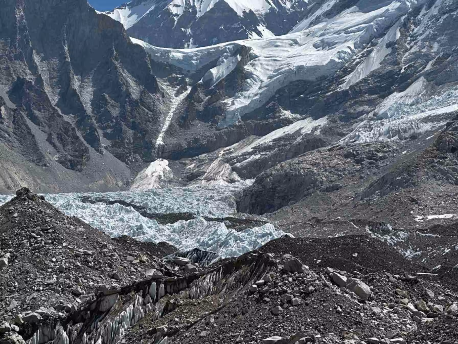
Route traverses spectacular landscapes from Syafru Besi through Langtang Valley reaching Kyangjin Gompa (3,870m), crosses to sacred Gosaikunda lakes (4,460m), then descends through traditional Helambu villages returning Kathmandu via Melamchi. This demanding but rewarding trek showcases diverse ecosystems, Tamang-Sherpa culture, dramatic mountain panoramas including Langtang Lirung, and wildlife encounters creating ultimate Langtang region experience.
Trek Overview and Route Description
Comprehensive Circuit Journey
Circuit uniquely combines three distinct trekking experiences typically done separately. Langtang Valley section provides classic glacier valley trekking with Buddhist monastery culture. Gosaikunda segment delivers sacred lake pilgrimage and high-altitude adventure. Helambu descent showcases traditional villages and terraced agriculture. Understanding route's comprehensive nature helps appreciating diverse experiences within single journey.
Total distance approximately 170 kilometers over 14 active trekking days. Elevation ranges 1,550-4,610 meters (Laurebina Pass) requiring excellent acclimatization. Daily walking averages 5-8 hours through varied terrain from river valleys to alpine passes. This ambitious itinerary demands good fitness, previous multi-day trekking experience, and altitude comfort.
Wildlife and Natural Diversity
Langtang National Park protects diverse ecosystems supporting rare wildlife. Red pandas inhabit rhododendron forests though rarely seen. Himalayan tahr frequent rocky slopes near Kyangjin. Bird species include Himalayan monal, blood pheasant, and various raptors. Understanding protected area status creates appreciation for conservation efforts balancing tourism and environmental protection.
Forest composition transitions from subtropical oak and rhododendron at lower elevations to alpine scrub and meadows above 3,500 meters. Spring rhododendron blooms transform forests into spectacular floral displays. Understanding ecological zones enriches appreciation beyond scenic beauty recognizing complex mountain ecosystems.
Detailed Itinerary Breakdown
Days 1-2: Kathmandu to Syafru Besi
Arrival Kathmandu includes airport pickup, hotel transfer, and comprehensive trek briefing covering route, altitude considerations, cultural protocols, and equipment checks. Second day features seven-eight hour scenic drive to Syafru Besi (1,550m) through terraced farmlands and increasingly mountainous terrain. Basic teahouse accommodation introduces mountain lodge culture.
Days 3-5: Syafru Besi to Kyangjin Gompa via Langtang Valley
Six-seven hour trek to Lama Hotel (2,470m) follows Langtang Khola through dense forests alongside river. Trail's moderate difficulty suits acclimatization beginning. Wildlife sightings include langur monkeys and diverse birds. Continuation to Langtang village (3,430m) takes five-six hours passing through Ghoda Tabela with valley opening revealing spectacular mountain views.
Final push to Kyangjin Gompa (3,870m) requires four-five hours through increasingly alpine terrain. Ancient Buddhist monastery, cheese factory, and surrounding peaks create iconic Langtang Valley destination. Understanding valley's devastating 2015 earthquake impacts—which killed hundreds and destroyed villages—creates somber appreciation for community resilience and reconstruction efforts.
Day 6: Kyangjin Acclimatization and Tserko Ri
Crucial rest day allows altitude adaptation while exploring surrounding areas. Popular option involves predawn Tserko Ri (4,984m) climb taking four-five hours providing spectacular sunrise over Langtang range. Panoramic views include Langtang Lirung (7,227m), Dorje Lakpa, Ganesh Himal, and Tibetan peaks. Alternative involves shorter valley walks, cheese factory visits, or monastery exploration.
Day 7: Kyangjin to Lama Hotel
Retracing ascent route provides different perspectives on familiar landscapes. Seven-eight hour descent covers significant distance though downhill nature eases cardiovascular demands while challenging knees. Understanding descent's physical demands helps pacing and preventing injury.
Days 8-10: Lama Hotel to Gosaikunda via Thulo Syafru and Sing Gompa
Alternative route diverges from ascent trail reaching Thulo Syafru (2,210m) after five-six hours. Continuation to Sing Gompa (3,330m) gains altitude through forests and traditional villages. Five-six hour trek to Gosaikunda (4,460m) traverses alpine meadows reaching sacred lake cluster. Multiple smaller lakes surround main Gosaikunda creating spiritually significant landscape revered by Hindus and Buddhists.
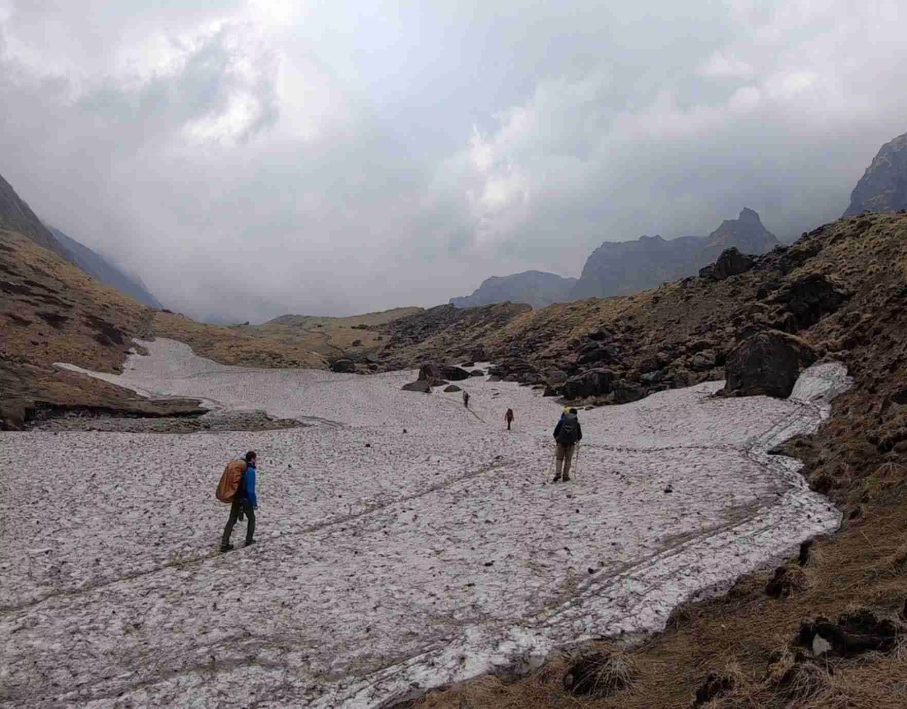
Day 11: Gosaikunda to Ghopte via Laurebina Pass
Most challenging day crosses Laurebina Pass (4,610m) at trek's maximum elevation. Six-seven hours involves steep ascent from Gosaikunda followed by dramatic descent to Ghopte (3,430m). Pass crossing requires early start avoiding afternoon weather deterioration. Snow possible any season requiring appropriate preparation. Understanding this section's difficulty helps mental and physical preparation.
Days 12-15: Helambu Descent via Traditional Villages
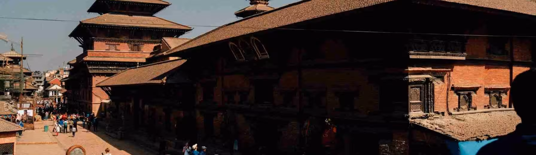
Gradual descent through Helambu region showcases traditional Sherpa and Tamang villages maintaining centuries-old lifestyles. Melamchi Gaun, Tarkeghyang, and Shermathang feature distinctive architecture, active monasteries, and terraced agriculture. Six-eight hour daily walking allows cultural immersion observing daily village activities, religious practices, and traditional crafts.
Understanding Helambu's distinct Sherpa culture—different from Everest region's Khumbu Sherpas—enriches appreciation for ethnic diversity within broadly similar Buddhist traditions. Village homestay opportunities provide authentic cultural exchanges though basic teahouse accommodation remains standard.
Day 16: Shermathang to Kathmandu via Melamchi Bazaar
Final trekking day descends to Melamchi Pul Bazaar where vehicles await for Kathmandu return. Five-six hour drive provides gradual transition from mountain environment to urban capital. Arriving Kathmandu allows celebration, final city exploration, and souvenir shopping in Thamel.
Cultural Immersion and Local Communities
Tamang Heritage
Tamang people dominate lower elevations maintaining Tibetan Buddhist traditions, language, and customs. Traditional architecture features stone houses with slate roofs. Agricultural practices include potato, millet, and vegetable cultivation. Understanding Tamang history including historical marginalization creates appreciation for contemporary community resilience and cultural preservation.
Sherpa Communities in Helambu
Helambu Sherpas demonstrate cultural variations from famous Everest region cousins while sharing Buddhist faith and Tibetan origins. Monasteries feature distinctive architectural styles and religious practices. Observing butter lamp offerings, prayer wheel rotations, and daily rituals provides insights into living Buddhist traditions.
Post-Earthquake Recovery
2015 earthquake devastated Langtang region killing over 300 people including trekkers and destroying entire villages. Reconstruction efforts rebuilt teahouses, trails, and communities though scars remain visible. Understanding disaster's impacts and ongoing recovery demonstrates community resilience while encouraging sensitive tourism supporting economic revival.
Physical Preparation and Difficulty Assessment
Fitness Requirements
Demanding 17-day itinerary requires excellent cardiovascular fitness, leg strength, and endurance. Daily elevation changes 500-1,200 meters challenge even experienced trekkers. Previous multi-day trekking experience highly recommended. Understanding circuit's cumulative fatigue helps realistic self-assessment and preparation.
Altitude Considerations
Maximum elevation 4,610 meters at Laurebina Pass creates significant altitude exposure. Gradual ascent through Langtang Valley provides crucial acclimatization though Gosaikunda-Ghopte section still challenging. Recognizing altitude sickness symptoms and accepting rest days when needed prevents serious problems. Previous high-altitude experience beneficial though not essential with proper pacing.
Technical Challenges
While no technical climbing required, trail sections involve steep rocky paths, potential snow on passes, and challenging stream crossings during monsoon. Trekking poles highly recommended for stability and joint protection. Understanding terrain variety helps appropriate preparation and equipment selection.
Best Trekking Seasons
Autumn Optimal Period
September through mid-December provides peak conditions with post-monsoon clarity offering spectacular mountain views. Comfortable temperatures and stable weather create ideal trekking environment. However, increased visitor numbers especially October-November. Understanding seasonal tradeoffs guides timing decisions.
Spring Alternative
March-May features blooming rhododendrons transforming forests into colorful gardens. Generally clear weather though pre-monsoon haze develops late season. Moderate temperatures and fewer trekkers than autumn. Understanding spring conditions helps planning appropriate timing.
Monsoon and Winter Avoidance
June-August monsoon brings heavy rainfall creating dangerous trail conditions, leeches, and cloud-obscured views. High passes potentially blocked by snow. Winter (December-February) features extreme cold and snow accumulation closing high passes. Most teahouses close limiting accommodation options. Understanding seasonal limitations prevents dangerous situations.
Permits and Logistics
Required Documentation
Langtang National Park Permit costs NPR 3,000 for foreigners. TIMS card requires NPR 2,000. Total permit costs approximately NPR 5,000 ($40-50 USD). Valid passport, comprehensive travel insurance covering 5,000+ meters, and visa documentation essential. Permits obtained through trekking agencies or tourism board offices.
Guide and Porter Services
While independent trekking allowed, hiring guide provides navigation security, cultural interpretation, and emergency support. Porter services reduce physical burden allowing enjoyment focus. Understanding guide/porter benefits helps deciding service levels matching personal preferences and abilities.
Costs and Budgeting
Complete 17-day organized treks typically $1,200-1,800 per person including permits, guide, accommodation, meals, and transportation. Costs vary by group size and service level. Budget planning should include personal expenses, equipment rental, emergency funds, and gratuities.
Frequently Asked Questions
How does this compare to other Langtang treks?
This comprehensive circuit combines Langtang Valley, Gosaikunda, and Helambu typically done separately. Longer duration, higher difficulty, more diverse experiences though requiring greater time commitment and fitness.
Can itinerary be shortened?
Yes, though eliminating sections reduces comprehensive experience. Minimum recommended 14 days. Consulting detailed Gosaikunda Trek information helps understanding segment options.
What about teahouse availability?
Good teahouse network throughout route though facilities basic. Remote sections between Gosaikunda and Helambu have fewer options requiring flexibility. Peak season availability better than shoulder seasons.
Is previous high-altitude experience necessary?
Highly beneficial though not essential. Gradual Langtang Valley acclimatization prepares for higher sections. Conservative pacing and altitude awareness more important than previous experience.
What wildlife might I see?
Red pandas rare though possible in rhododendron forests. Himalayan tahr common near Kyangjin. Numerous bird species including monal pheasants. Understanding that wildlife sightings never guaranteed prevents disappointment.
Can I do circuit reverse direction?
Technically possible though less common. Standard direction provides better acclimatization profile. Reverse direction faces steeper Laurebina Pass ascent from Helambu side.

No comments yet. Be the first to share your thoughts!