Annapurna Circuit Trek (ACT)

Annapurna Circuit Trek (ACT)

Every access point on ACT route sits on a road. Expect basic rooms along the trail: twin beds, a shared bathroom. Watch sunrise light up the Annapurna and Dhaulagiri ranges from Poon Hill.

★★★★★ 5 (2 reviews)
Duration 12 days
Max Altitude 5,416m
Per day walk 5-7 hours
Accommodation Teahouses
Difficulty Moderate to Challenging

For anyone new to the Himalaya, the Annapurna Circuit Trek (ACT) raises one question before anything else: can I do this?

Fitness and altitude decides the answer more than experience does.

To cross Thorong La, prepare to hike five to seven hours daily over rough ground and take proper care with the high altitude.It's an achievement you'll carry home with you for a long time.

If you have already trekked in places like Everest, Kilimanjaro, or the Alps, you will ask a different question. What does this route give me that the last one didn't?

Here's the honest answer:

One loop takes you from rice terraces and pine forest into the rain-shadow desert north of the Annapurna Massif. Then the route drops you through the deepest gorge on Earth.

You'll sleep in a teahouse every night during the trip. You don't have to worry about missing flights unlike Everest Trek flights.

The pass itself is the hardest test on the route, and it deserves a straight answer too.

Your guide will keep the Manang rest day at full length no matter how strong the group feels. Skipping or shortening the rest day in Manang is the main reason trekkers fail to reach the high pass.

One risk you won't face in this trek: a flight that gets canceled by weather, the way Everest Base Camp's Lukla flight can.

Every access point on this route sits on a road. The real weather risk sits at Thorong La itself. A storm above Manang can close the pass for a day or more, most often in winter or at the edges of the main season. If that happens, your guide holds the group at a lower village until conditions clear rather than push a dangerous crossing. It's worth building a day or two of slack into your return schedule.

Expect basic rooms along the trail: twin beds, a shared bathroom, and a dining hall stove as the only heat most nights. The view outside more than makes up for it.

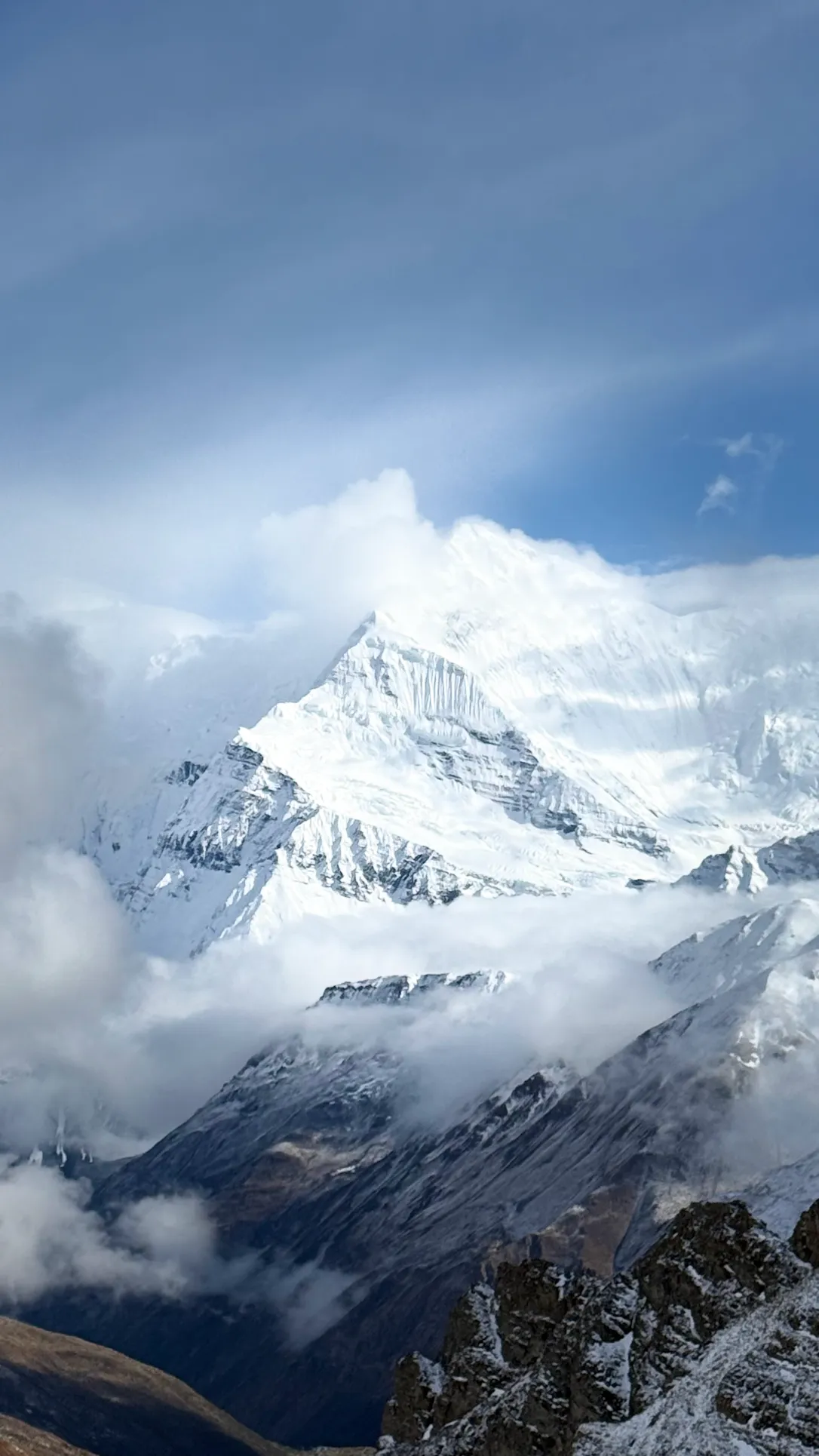
Annapurna II from Pisang and the full range from Ghyaru are the kind of thing no hotel room back home can offer. Neither is the sunrise wall of Annapurna and Dhaulagiri from Poon Hill.

Fitness matters more here than trekking experience does.

Two weeks of daily walking, 3 to 4 liters of water a day, and no alcohol above Manang. They all play a part in how your body handles the climb. So does trusting your guide's call to slow down when it counts, even if you feel fine.

When you're ready to book, Mountain Routes runs this trek as a fixed group departure or a private trip on dates you choose, both at the same price.

Most people book online, but if you'd rather talk your dates and fitness through with a real person first, just message the team before you commit.

Annapurna Circuit Trek Highlights

  • Cross Thorong La Pass at 5,416 m, the highest point of the circuit, before dawn
  • Watch sunrise light up the Annapurna and Dhaulagiri ranges from Poon Hill
  • Rest and acclimatize in Manang, a Tibetan-style town at 3,519 m
  • Visit Muktinath, a pilgrimage site sacred to both Hindus and Buddhists, with its 108 water spouts
  • Descend through the Kali Gandaki gorge, the deepest on Earth
  • Soak your legs in the natural hot springs at Tatopani
  • Walk from green river valleys to high alpine desert on one continuous route
  • Pass through Gurung, Manang, and Thakali villages, monasteries, and prayer walls

Annapurna Circuit Trek at a Glance

Here's the whole Annapurna Circuit Trek in one table. The day-by-day detailed itinerary further down answers the rest of your questions.

Item

Detail

Duration

12 days

Highest point

Thorong La Pass, 5,416 m / 17,769 ft

Start point

Drive Kathmandu to Besisahar

End point

Tadapani to Nayapul, then Pokhara

Route type

Circuit, walked anticlockwise

Difficulty

Moderate to challenging

Daily walking

5 to 7 hours

Best months

September to November, March to May

Accommodation

Teahouses on the trail

Total distance

160 to 230 km (apprx.), depending on the road sections used.

Communities

Gurung, Manang, Thakali

A Typical Day on the Annapurna Circuit Trek

Your day starts before the sun fully clears the ridgeline.

Most teahouses serve breakfast between 6:30 and 7:30. Your guide uses that half hour to walk the group through what's coming: how far, how steep, and where the altitude starts to matter.

You'll be on the trail by 7:30 or 8, since afternoon cloud and wind build fast above 3,000 m, and an early start gets you to camp with daylight to spare.

The walking itself runs in blocks. A morning stretch of 2 to 3 hours brings you to a trailside teahouse for lunch, usually dal bhat, noodles, or a fried rice bowl. It's a proper sit-down break, not a granola bar on the move.

The afternoon leg is shorter, and you'll typically reach the next village by early to mid afternoon, well before dark. That's not an accident. Building slack into every day is part of how the acclimatization plan works. It gives you time to actually enjoy where you've ended up, rather than just collapsing into it.

Once you arrive, the rhythm shifts. Boots come off, and you claim a room.

You'll usually have a couple of hours before dinner. That's time to wash up, hang out in the dining hall, write in a journal, or just watch the light change on the peaks outside.

Your guide checks in with everyone at this point, not with a clipboard but with a few simple questions: how did you sleep, any head pain, any change in appetite. It's a low-key moment, but it's exactly how altitude problems get caught early instead of late.

Dinner runs around 6:30 or 7, and most trekkers are in bed well before 9, since the next day starts the same way all over again.
Annapurna Circuit Itinerary: 12-Day Route

Your route climbs through three distinct zones, and knowing the shape of the trip in advance makes each day easier to picture.

Days 1 to 3 follow the green Marsyangdi valley through pine forest and farm villages. Days 4 to 7 cross the dry, high-altitude zone above the tree line, where the geography turns to open scree and wind.

Days 8 to 11 drop you into the Kali Gandaki side, through hot springs, rhododendron forest, and terraced Gurung country.

Each day below carries its altitude gain and the real waypoints along the way, so you know exactly what's coming.

Your trip starts with a long scenic drive along the Prithvi Highway, leaving Kathmandu behind as you follow the path of the Trishuli River. This initial road journey takes you through the beautiful Nepalese mid-hills, past terraced fields, green hillsides, waterfalls, and traditional riverside towns that define the lower landscape. 

The drive from Kathmandu to Besisahar runs about 6 to 7 hours by local bus or private vehicle.Although traffic and road conditions might affect the timing. 

Besisahar serves as the traditional entry point for the classic loop. The road snakes past terraced fields, green hillsides, and river valleys that define the lower landscape before you start walking. You'll spend your first night in Besisahar preparing for the trail ahead.

Today's journey tracks the Marsyangdi River via rugged mountain roads as you advance deeper into the mountain range. On the way to Chame, the administrative hub of the Manang district, you will travel through the settlements of Dharapani and Bagarchhap. It is here that Lamjung Himal first comes into clear view. You will stay overnight in Chame, getting ready for the higher altitude trails to come.

We begin our trek with a forested trail that opens up to rocky cliffs and thundering, roaring rivers. As the valley narrows, the massive peaks draw much closer, leading us through trail stretches where stone houses with slate roofs cling tightly to the steep hillsides. The trail hugs the cliffside above the thundering waters of the Marsyangdi River. It takes us through a dramatic, narrow gorge before opening up into a wide valley landscape filled with beautiful apple orchards.

Along the journey, we cross several suspension bridges and pass through charming villages, including small hamlets, barley fields, and open grazing grounds. You will pass through the peaceful settlements of Bhratang and Dhukur Pokhari, which serves as a common trailside lunch area. The full scale of the Annapurna range begins to reveal itself, highlighted by spectacular views of Lamjung Himal and Annapurna II standing directly over the route.

Before arriving at our destination, you witness the iconic Paungda Danda rock face, a massive and dramatic curved rock wall rising seamlessly from the riverbed. The trail then leads us to the peaceful village of Pisang for an overnight stay.

Two paths lead toward Manang today, and your guide will steer you toward the higher route via Ghyaru and Ngawal. It is the steeper and more exposed choice. The payoff is a 360-degree wall of Annapurna II, Annapurna III, Gangapurna, and Pisang Peak that the lower road simply cannot match. 

You will cover 17 kilometers over 6 to 7 hours as the valley opens into a high, barren rain-shadow desert. Both trails rejoin near Braga, where you will stop at the ancient Barge Monastery, a central spiritual site for the valley. Your day ends in the bustling Tibetan-style hub of Manang at 3,519 m. You will spend the next two nights here, a mandatory pause to let your body adjust before the trail climbs any higher.

To maximize the value of your mandatory Manang rest day, we follow the "climb high, sleep low" rule with two specific hiking choices. Depending on your energy, your guide will lead you on a steady climb to the historic Bhojo Gumba or a shorter walk to the glacial waters of Gangapurna Lake.

Both side trips are an active investment in your acclimatization before the trail heads higher. The rest of your day belongs to the village itself: you can visit the local bakeries, stop by the Himalayan Rescue Association clinic, or simply watch the Tibetan-style life of the town unfold. You'll return to the same lodge for dinner and a second night of rest, ensuring your body is fully recovered for the climb toward Yak Kharka.

The trail follows the valley past Tenki, where the upper and lower routes rejoin, then continues through Gunsang into increasingly open, treeless country. Yak herds graze the slopes on either side. Yak Kharka itself is little more than a cluster of stone lodges built for one purpose: the last comfortable sleep before the climb gets serious. Walking time runs 3 to 4 hours, kept deliberately short to protect your acclimatization curve.

Altitude gain: +310 m. Today includes one of the route's more exposed stretches, a section near Ledar where the trail sometimes reroutes slightly depending on recent landslide activity. Follow your guide's lead closely here. A suspension bridge crossing leads into a rising traverse toward the base of the pass. Thorong Phedi means "foot of the pass" in Nepali, and the name fits. It's a small huddle of lodges at the base of a wall of scree, with nothing between it and tomorrow's climb. Walking time runs 3 to 4 hours.

Some choose to push past Yak Kharka directly to Thorong High Camp. While moving higher tonight makes tomorrow's crossing shorter, staying at Thorong Phedi instead is the safer call for your acclimatization. No matter which lodge you pick, your main priority stays the same: drink plenty of water and get as much rest as you can.

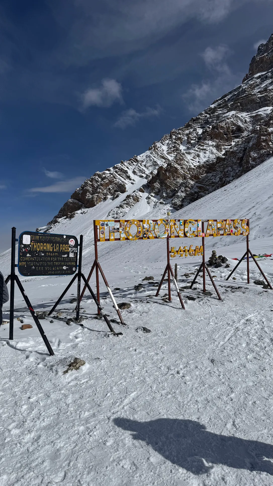
Altitude gain: +996 m up, then 1,706 m down, in the same day. This is the day everything else has been building toward. You'll start before dawn, usually between 3 and 5 am, to beat the afternoon wind that regularly picks up on the pass. The climb is steady switchbacks rather than anything technical, and prayer flags and a stone cairn mark the top when you get there. What follows is a long, knee-jarring descent to Muktinath, broken up by a small teahouse partway down where most trekkers stop for tea before finishing the drop. Muktinath itself is a pilgrimage site sacred to both Hindus and Buddhists, known for its 108 stone water spouts and an eternal flame that burns beside a natural spring. Walking time runs 7 to 8 hours, and your legs will know it by the end.

Today is a driving day down the Kali Gandaki, the deepest gorge on Earth, following the road from Muktinath through Jomsom toward Tatopani. Jomsom is the district headquarters, with a small airstrip and your last real services before the valley narrows again. Tatopani means "hot water," and its natural hot springs are exactly what your legs want after yesterday's pass. Drive time runs 5 to 6 hours.
OR

You have the choice to drive straight to Marpha or walk the stretch from Jomsom to claim a bed there for the night. As the district capital, Jomsom provides the final cluster of real services and a mountain airstrip before you push deeper. Here, the landscape transitions into the wind-sculpted, lunar desert of the Mustang rain-shadow, nestled between the towering walls of Annapurna I and Dhaulagiri. 

Your destination, Marpha, is a classic Thakali village of white-washed stone, better known on the trail for its apple orchards and the brandy they produce.

Altitude gain: +1,660 m, the biggest single-day climb of the trip. The trail rises steadily from the Kali Gandaki floor through Ghara, Sikha, and Chitre, trading river valley heat for green terraces and farm villages. As you push higher, the route enters deep oak and rhododendron forest that turns the whole hillside red if you arrive in spring. Ghorepani sits on a ridge just below the Poon Hill viewpoint, and most trekkers reach its lodges with one thing on their mind: tomorrow's sunrise. Walking time runs 7 to 8 hours, and you will spend the night in a Ghorepani teahouse.

Altitude gain: +360 m before dawn, then a descent through forest. A short, steep pre-dawn climb takes you to the Poon Hill viewing tower in time for sunrise. The payoff is a full wall of Annapurna and Dhaulagiri peaks lit up by first light, one of the most photographed views in Nepal. After sunrise, you'll descend back through Ghorepani and continue through oak and rhododendron forest to Tadapani. Walking time runs 6 to 7 hours.

Your descent today runs through forest into Gurung country, arriving at Ghandruk, a terraced hillside village with Machhapuchhre and Annapurna South standing directly overhead. From Ghandruk, the trail continues down to Kimche and Nayapul, where a vehicle picks you up for the drive to Pokhara. Walking time runs 5 to 6 hours plus a 1-hour drive.

Annapurna Circuit Route Map

The elevation profile below tells you more about this trek than the itinerary text alone can. Your route climbs from Kathmandu at 1,400 m to Thorong La at 5,416 m, a rise of roughly 4,000 m spread across seven days. It then drops all the way to Pokhara at 822 m over the days that follow. Across the full 12 days, you'll climb an estimated 6,000 m and descend close to 6,600 m in total. 

Annapurna Circuit Elevation Profile

The shape of the profile matters as much as the total. Notice the steady staircase up through Chame, Pisang, and Manang, three days that gain altitude gradually on purpose. A flatter stretch through Yak Kharka and Thorong Phedi follows, keeping your daily gain small right before the pass. Then the chart shows the sharpest line on the whole trek: the climb to Thorong La and the long drop to Muktinath, both in a single day. It's more elevation change than any other day of your trip. After the pass, the profile flattens again through the Kali Gandaki valley before one last climb to Ghorepani and Poon Hill.

Kathmandu 1,400m
Besisahar 760m
Chame 2,710m
Pisang 3,300m
Manang 3,519m
Yak Kharka 4,020m
Thorang Phedi 4,540m
Thorong La Pass 5,416m
Muktinath 3,800m
Tatopani 1,190m
Ghorepani 2,874m
Poonhill 3,210m
Tadapani 2,610m
Nayapul 1,070m
Pokhara 822m

How Many Days Does the Annapurna Circuit Take?

Route

Start

Days

Distance(apprx)

Classic Annapurna circuit trek

Besisahar

12 days

160 to 230 km

Short Annapurna circuit Trek

Besisahar

7 days

120 to 150 km

Circuit with Tilicho Lake

Besishar

12 to 14 days

140 to 160 km

Circuit with North ABC

Besishar

13 to 15 days

170 to 190 km

Circuit with South ABC

Besisahar

15 to 22 days

Road access to Manang and Muktinath now lets you start or end the loop partway in, which is what makes the 7-day short circuit possible without skipping the pass. If you have more time, you'll want to add Tilicho Lake at 4,919 m or a side route toward Annapurna Base Camp.

  • Choose the full circuit if you want the complete route and the deepest acclimatization curve, the safest choice for your first high-altitude trek.
  • Choose the short circuit if your schedule is tight, since it still crosses Thorong La without the lower valley approach.
  • Choose the Tilicho or North ABC add-on if you'd rather trade extra days for a second high point past the pass itself.

How Difficult Is the Annapurna Circuit Trek?

The Annapurna Circuit rates moderate to challenging, and length and altitude drive that grade, not technical terrain. You won't need ropes, climbing skill, or glacier travel anywhere on this route. What it asks for instead is endurance across twelve days, comfort walking 5 to 7 hours on rough ground, and respect for one hard day at 5,416 m.

Three things decide whether you'll find it hard:

  • Altitude. The pass day is the real filter. If you keep the Manang rest day and follow your guide's pace, you'll cross it; trekkers who rush the middle days are the ones who turn back.
  • Consecutive days. No single day except the pass is extreme, but twelve in a row wears down legs that haven't trained. Two to three months of regular hill walking beforehand changes the whole experience for you.
  • Descent. Day 7 loses 1,706 m after the pass, and Day 10 drops steeply from Poon Hill. Your knees will feel this route as much as your lungs do, so bring trekking poles.

Who this trek suits:

  • First-time Himalayan trekkers with steady general fitness and two to three months to train.
  • Experienced trekkers from other regions or countries, who'll find the one real test rather than the whole trip.
  • Fit hikers whose experience is mostly flat or low-altitude trail, as long as they train for altitude in particular and take the Manang rest day seriously.
  • Trekkers across a wide age range, given adequate preparation.

How Much Does the Annapurna Circuit Trek Cost?

Your Annapurna Circuit Trek cost scales with group size, and the price below is the complete package, not a guide-only rate with extras added later.

Package price by group size

Group size

Price per person (USD)

1 trekker

1,220

2 to 4 trekkers

950

5 to 10 trekkers

900

11 to 15 trekkers

850


Here's why the price drops as your group grows: several of the biggest costs on this trek stay fixed no matter how many people share them.

A jeep to the trailhead costs the same whether it carries one trekker or ten. One guide leads a group of two just as easily as a group of eight. When more trekkers split those fixed costs, everyone's share gets smaller.

Costs that scale directly with each person, like your food, your teahouse bed, and your share of the porter team, stay roughly the same regardless of group size. That's why the price curve flattens out rather than keeps dropping past 11 to 15 trekkers.

For independent trekkers skipping the guided package, the daily budget runs roughly 20 to 30 US dollars for food and lodging on the trail. Bottled water and hot showers cost more the higher you climb.

Tipping your guide and porters

Tipping isn't included in your package price, and it stays entirely your choice, but it's a normal part of trekking in Nepal and worth planning for.

The usual practice is a pooled tip on the last evening: one envelope for your guide and one shared among the porters, with the guide receiving the larger share.

Bring cash for this, in Nepalese Rupees or US dollars, since no card machine exists on the trail.

What does the Annapurna Circuit Trek Package Includes and Excludes ?

Your Annapurna Circuit package covers everything you need to walk the route without chasing logistics on arrival. A few costs sit outside every Annapurna Circuit package by industry standard, and it's worth knowing them now rather than being surprised later.

If unforeseen weather or health issues extend your trip, a daily charge of roughly 85 to 100 USD applies.

Included

  • Airport transfers in Kathmandu on arrival and departure
  • Road transport from Kathmandu to the trailhead and back from Pokhara
  • Two nights of hotel in Kathmandu and one night in Pokhara, with breakfast
  • All trail meals: breakfast, lunch, and dinner
  • Teahouse accommodation on the trail
  • One government-licensed guide per departure
  • One porter for each pair of trekkers Insurance for your guide and porters
  • The ACAP permit
  • A first aid kit carried by your guide
  • A trek certificate, a company t-shirt, and a closing dinner

Excluded

  • International flights to Kathmandu
  • Nepal entry visa
  • Your travel insurance
  • Lunch and dinner in Kathmandu and Pokhara
  • Extra hotel nights
  • Bottled water, hot showers, and Wi-Fi on the trail
  • Personal spending
  • Tips for your guide and porters
  • Emergency evacuation, which runs at cost through your insurance

Altitude Sickness and Safety during trekking the Annapurna Circuit

Altitude risk starts above roughly 3,000 m on Annapurna Circuit trek route, and the whole plan is built around it. You'll get a full rest day at Manang, 3,519 m, before the climb continues. Your guide watches for head pain, dizziness, poor sleep, and loss of appetite, and holds to one golden rule throughout the upper days: climb high, sleep low.

Your travel insurance for this trek of Annapurna Circuit needs to cover helicopter evacuation up to 5,416 m, since standard holiday policies often stop well below trekking altitude.

Muktinath, Manang, and the Jomsom road all give helicopter access if you need to come down fast.

A pre-trip visit to a travel doctor is a good idea if you have heart, lung, or blood-pressure conditions, or if you're new to high altitude generally. Any guidance on altitude medication belongs with that doctor, not on a trek page.

Medical Facilities on the Route of ACT

While medical services on the trail are basic, key support is available at specific hubs.

Besisahar serves as the main entry point with local district health services. In Manang, trekkers have access to the Himalayan Rescue Association (HRA) clinic, which is highly recommended for altitude-related advice and acclimatization briefings.

Jomsom, as the district headquarters, provides broader medical services. Muktinath also has a local medical post.

Trekkers should always carry a personal first-aid kit stocked with regular medications and consult a travel doctor before the trip.

For emergencies, ensure your travel insurance explicitly covers helicopter evacuation from high-altitude regions up to 5,416 m.

Best Time to Trek the Annapurna Circuit

The best time to trek the Annapurna Circuit splits across two windows.

Autumn (September - November) holds the steadiest weather: skies stay clear, trails stay dry, and the pass holds stable conditions for your crossing.

Spring (March - May) comes a close second. Mountain visibility runs slightly hazier than autumn most years, but you'll get rhododendron forest in bloom across the lower trail and thinner crowds early in the season.

Winter (December-February) brings deep cold and snow above 3,500 m, and Thorong La often closes under ice.

Summer (June-August) overlaps the monsoon, with rain, leeches, and clouds that hide the peaks on the lower trail. Both shoulder windows reward a flexible travel date if your schedule allows it.

Teahouses and Food on the Annapurna Circuit

Teahouses are your only accommodation on the Annapurna Circuit, and the food follows a similarly simple, trail-tested pattern at every stop.

Rooms and comfort on the trail

Expect small, family-run lodges with twin rooms, warm blankets, and shared washrooms. Comfort drops as you climb, so the highest nights stay basic, with no heating outside the dining hall stove.

Menus lean on dal bhat, noodles, soup, pasta, and eggs, and vegetarian plates are your safest choice the higher you go.

Hot showers and Wi-Fi are available at most teahouses, priced per use, and the cost rises fast above Manang.

A filter bottle or purification tablets will save you money and cut down on plastic, since bottled water gets pricey and heavy the higher the trail climbs.

Food safety on the trail

A few simple habits keep your stomach on your side for the whole trip.

Stick to hot, freshly cooked food, and go easy on raw salads and unpeeled fruit, since wash water on the trail isn't always purified.

Skip ice in drinks for the same reason.

Dairy gets riskier the higher you climb, since reliable refrigeration gets harder to find above the road, so save it for the lower villages.

A basic health kit earns its place in your daypack. Oral rehydration salts handle the most common trail complaint, an upset stomach, faster than anything else in your kit.

General pain relief and your own regular prescription medication round out the kit, packed in original containers with enough for the whole trip plus a few extra days.

Anything altitude-specific belongs with a travel doctor before you go, not on a packing list.

Permits for the Annapurna Circuit Trek

The Annapurna Conservation Area Permit is required and checked at points from Besisahar to the Jomsom area.

Foreign trekkers pay NPR 3,000, about 25 US dollars, and Mountain Routes arranges it as part of your package. A TIMS card has long been part of Annapurna paperwork, but enforcement on the circuit is under review for 2026.

Detailed information on Permits and Documents required for ACT

Do you need a guide to trek Annapurna Circuit?

Nepal now requires a licensed guide for most trekking regions, including the Annapurna Circuit.

Past the legal requirement, a guide gives you real safety on the pass day. Every Mountain Routes departure includes one.

What documents do you need to send, and when?

Two things process both permits before you land: a scan of your passport bio-page and passport-sized photos.  

Email or WhatsApp these at least 15 days ahead of your trip, so your permits sit ready to collect in Kathmandu rather than something you wait on after you arrive.

Local Communities and Customs on the Annapurna Circuit

Three distinct communities shape the route, and each stretch of trail will feel different because of it. 

Gurung villages fill the lower valley near Chame and Pisang, many with roots in Gurkha regiments that have served in British, Indian, and Nepali armies for two centuries.

A Gurung tradition worth knowing is the rodhi. It is a communal gathering house where young people sing and are courted through the evening. A lighter, social version of the custom is still alive in some villages today.

Manang itself belongs to the Manangi community, Tibetan Buddhist by faith. Their ancestors held a rare royal trading charter that let them travel and trade across Asia centuries before tourism arrived.

Braga Monastery and the smaller gompas scattered around Manang and Ngawal are living monasteries, not museum pieces. If you visit during a quiet lull between trekking groups, you'll often find a monk willing to explain a mural or a mani wheel. 

Thakali communities take over the pass, centered on Marpha, Tukche, and Jomsom in the Kali Gandaki valley. The Thakali once controlled the salt trade route between Tibet and India. That trading history shows up today in a distinct cuisine, the Thakali thali, built around buckwheat, apples, and a set of side dishes you won't find anywhere else in Nepal.

Muktinath, on the Thakali side of the pass, is sacred to both Hindus and Buddhists at once, a rare shared shrine rather than a divided one. When you visit, a few simple courtesies go a long way: walk clockwise around chortens, mani walls, and stupas, keeping them on your right hand.

Remove your shoes before entering a monastery or temple, and keep your voice low if a ceremony is underway. Ask before photographing a person, not just a building. A hand placed together with a quiet "Namaste" will carry you further than any guidebook phrase.

What to Pack for the Annapurna Circuit ?

Packing for Annapurna Circuit trekking route means packing for two treks at once: warm valley days low down, and one pre-dawn morning near minus 10 at the pass.

Your porter carries your main duffel between villages, with a load limit determined by the group size: if shared by 2 people, the limit is 10–12 kg per person, while for individual travellers, it is up to 20 kg.

Your daypack holds what the day itself needs: water, layers coming on and off, sun protection, and your camera.

From head to toe

  • Head and eyes:
    • a sun hat for the low valley,
    • a buff,
    • a warm beanie for the pass, and
    • sunglasses with strong UV protection. Sunlight at altitude burns fast, and snow near the pass doubles it from below.
    • Pack a headlamp with spare batteries, since your pass crossing starts before dawn.
  • Upper body:
    • moisture-moving base tops,
    • a fleece,
    • a down jacket, and
    • a waterproof shell. Cotton stays wet against your skin once you sweat, and wet clothing at altitude turns a rest stop cold fast. Stick to synthetics or wool as your base layer.
  • Hands:
    • thin liner gloves for most mornings,
    • insulated gloves for the pass. Your fingers go numb first on the crossing, and zips, poles, and your camera all need working hands.
  • Legs:
    • trekking trousers for the trail and thermal leggings underneath for the pass morning.
    • Shorts work fine low down in autumn, though modest lengths respect village norms along the whole route.
  • Feet:
    • broken-in boots,
    • wool trekking socks, and
    • light camp shoes for teahouse evenings. Your feet swell over two weeks of walking, and tired feet want out of boots the moment the day ends.

Trail gear

  • Trekking poles save your knees on the 1,706 m descent from the pass to Muktinath, the single longest downhill of the trip.
  • A sleeping bag rated for cold nights, since teahouse blankets thin out at the highest stops. Rentals in Kathmandu work well for this.
  • A refillable bottle with purification (filter, tablets, or UV) covers the whole route. Boiled water is on sale at every teahouse, and purified refills beat buying plastic uphill in both cost and waste.

Snacks and electronics

  • Pack a few energy bars,
  • electrolyte powder, and
  • a small stash of familiar snacks from home.

Teahouse menus repeat themselves after a week, and appetite often drops at altitude, so something that tastes like home helps more than it sounds like it would.

  • A power bank spares you the queue for a charging socket, and
  • a universal adapter covers Nepal's plug types (mainly C, D, and M) since teahouse outlets vary.

Spare camera or phone batteries lose charge faster in the cold, so keep one in an inside pocket close to your body on the coldest days.

Download offline maps before you leave Kathmandu, since the signal disappears for long stretches above Manang.

Health and hygiene

  • Sun protection:
    • high-SPF sunscreen and
    • SPF lip balm, applied before the burn, not after.
  • A blister kit and personal medication in your daypack, not your porter duffel, since the duffel travels separately.
  • Hand sanitizer, wet wipes, and toilet paper. Teahouses don't supply paper, and showers get cold, scarce, and pricey with altitude, so wipes carry the washing load on your high days.

For female trekkers

Pack menstrual supplies even when you're not expecting a period, since long days, altitude, and travel itself can shift a cycle. Pads are sold in Kathmandu and Pokhara pharmacies, but the choice thins fast past the road.

Tampons are not easily available unlike pads, so bring a full trip's supply from home. A menstrual cup cuts waste to nearly nothing, but it needs practice before the trail and clean hands to manage, so don't try it for the first time mid-trek.

Disposal is the part no packing list mentions: no bins exist between villages, and teahouse toilets take nothing non-degradable. Sealable bags for carrying used items to the next village bin are part of the kit, not an optional extra. A small dark-colored dry bag keeps this private and simple.

Nature rules that shape your packing

The whole route runs inside the Annapurna Conservation Area, and your packing follows its logic. Everything above the road arrives on a mule or a porter's back, and waste has no way down except the same way.

Carry your non-burnable rubbish out to a village bin. Used toilet paper on the trail goes into a bag, not under a rock. Refill and purify instead of buying bottled water, since every plastic bottle sold uphill becomes someone else's load to carry down.

Buy before you fly, or buy in Kathmandu?

Buy or prepare at home:

  • Boots, worn in for weeks first. New boots cause the blisters that end treks, and no shop in Thamel fixes that in a day. The one item that must not fail gets no shortcut, which is why your boots come from home.
  • Base tops, socks, and anything fit-critical, including a well-fitted sports bra for two weeks of daily walking.
  • Prescription medication and prescription sunglasses, plus a menstrual cup if that's your plan, practiced before departure.

Buy or rent on arrival in Kathmandu or Pokhara:

  • Down jackets and sleeping bags rent cheaply in Thamel and return after your trek. You can buy/rent from locally sourced materials or choose the branded ones as you like.
  • Trekking poles, hats, gloves, and purification tablets are everywhere and cost little.
  • Toiletries, snacks, and toilet paper restock in Kathmandu, Pokhara, and larger trail villages.

5/5
★ ★ ★ ★ ★
2 reviews
5
2
4
0
3
0
2
0
1
0
I
Isabella Traveler
★ ★ ★ ★ ★

Trekked in May 2026

We had an amazing experience with Mountain Routes during our Annapurna Circuit Trek. From the very beginning, the communication was smooth, fast, and completely uncomplicated. The team took great care of us throughout the entire trip and made us feel safe and well looked after at all times.

The whole tour was perfectly organized, and we always knew what the next steps were, which made the experience very relaxing and enjoyable. Everything was planned professionally and ran without any issues.

We are extremely satisfied and would choose Mountain Routes again anytime. Clear recommendation for anyone planning a trek in Nepal!

T
Theo Traveler
★ ★ ★ ★ ★

Trekked in May 2026

A local company that is truly exceptionally well organized. The tour was planned completely individually and tailored to our needs. Even last minute changes were no problem at all, and they always adapted everything to make sure we had the best possible mountain experience. Communication was excellent throughout the entire process. During the tour, it never felt like we were traveling as guests, but rather with friends.

100% recommendation! - Annapurna circuit

Questions Trekkers Ask Most

Difficulty and Comparison

Both routes reach a similar altitude, near 5,400 m. Many trekkers find the Annapurna Circuit tougher underfoot on the long pass day, while the wider daily range on this route can help your acclimatization. Your fitness and pacing decide more than the label does.

Thorong La sits at 5,416 m, the highest point of the circuit. Your climb starts before dawn from Thorong Phedi(4,540m) or Thorong High Camp(4,850m) to beat the afternoon wind.

The trek to Thorong La takes approximately 4 hours when starting from Thorong High Camp, compared to about 5 hours from Thorong Phedi. The descent to Muktinath runs long on tired legs. It's the single hardest day of the trip, not a stretch of many hard days.

Starting From
USD 1,220
per person

Success!

Send us your query about the Trip.
Request a Free Callback

Fill in your details and our travel expert will call you within 24 hours.

Loading...
Send Inquiry

Have questions or want to customize your trip? Fill out the form below and our travel experts will get back to you within 24 hours.

Quick Response We typically respond within 2-4 hours during business hours.