
Sarangkot hilltop rises to 1,600 meters on Pokhara's western edge, offering unobstructed Himalayan panoramas and Phewa Lake views.
Among Pokhara's most visited viewpoints, this accessible summit rewards modest hiking efforts with spectacular mountain scenery including Dhaulagiri (8,167m), Annapurna I (8,091m), Manaslu (8,163m), and over twenty other peaks exceeding 6,000 meters. Clear mornings reveal the entire Annapurna range stretching across northern horizons while Phewa Lake spreads below reflecting mountain images.
Beyond mountain viewing, Sarangkot functions as adventure sports hub. International recognition as world-class paragliding site attracts thrill-seekers launching from hilltop slopes gliding over Pokhara Valley. Zipline starting point provides adrenaline rush descending toward valley floor. Traditional villages surrounding viewpoint offer cultural immersion opportunities. Wildlife including occasional leopard sightings adds exotic element though encounters remain rare.
Accessibility makes Sarangkot suitable for various fitness levels and time constraints. Vehicle road reaches near summit allowing quick visits. Hiking trails from Pokhara provide exercise and gradually revealing scenery. Extension options to Naudanda village create longer day trips. Understanding access options, best viewing times, and available activities helps maximize limited time in Pokhara region while experiencing quintessential Himalayan viewpoint.
Understanding Sarangkot's Geography and Views
Strategic Hilltop Position
Sarangkot occupies isolated hill separated from Annapurna foothills by Pokhara Valley. This positioning creates unobstructed sightlines toward Himalayan peaks without foreground mountains blocking views. Elevation at 1,600 meters provides sufficient height revealing distant peaks while remaining accessible without altitude concerns. Combination of accessible elevation and strategic position explains Sarangkot's viewpoint supremacy.
Western location relative to Pokhara optimizes morning light. Sunrise illuminates mountains from east creating golden alpenglow on white peaks. Photographers particularly value these conditions producing dramatic images. Evening visits show different lighting though morning generally preferred for clarity and color. Understanding light dynamics helps timing visits for desired photographic or viewing results.
Mountain Panorama Details
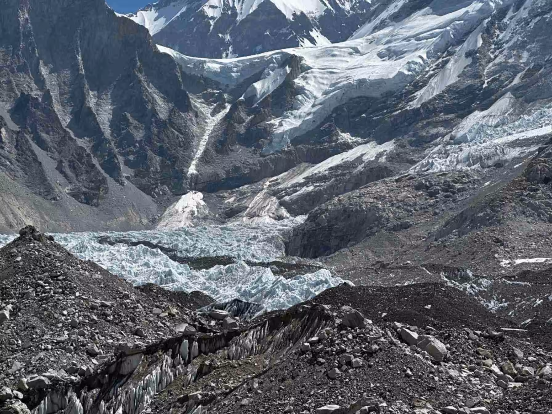
Northern horizons display remarkable mountain density. Dhaulagiri massif dominates northwest as world's seventh-highest peak. Annapurna range stretches east showing multiple summits including Annapurna I (tenth-highest globally), Annapurna South, Hiunchuli, and Gangapurna. Machapuchare's distinctive pyramid rises prominently despite lower elevation due to proximity and dramatic profile. Manaslu appears east on exceptionally clear days.
Over twenty peaks exceeding 6,000 meters create overwhelming Himalayan spectacle. Lamjung Himal, Annapurna II, III, IV, and numerous subsidiary peaks fill gaps between major summits. Snow coverage varies seasonally with post-monsoon period (October-November) showing maximum accumulation. Understanding which peaks appear where enhances identification and appreciation rather than simply admiring undifferentiated white mass.
Phewa Lake Views
Looking southward, Phewa Lake spreads across valley floor showing irregular shoreline and island temple. Morning still water creates mirror reflections doubling mountain images. Afternoon breezes ripple surface destroying reflections but animating landscape with movement and light play. Understanding lake perspectives from elevation reveals geographic relationships unclear from shore level.
Pokhara urban development visible south and east shows valley's rapid growth. Comparing current development with older photographs reveals dramatic urbanization impacts. Some lament lost rural character while others appreciate improved infrastructure and opportunities. Aerial perspective encourages reflection on development versus preservation tensions facing Nepal.
Hiking Routes and Access Options
Lakeside to Sarangkot Hiking Trail
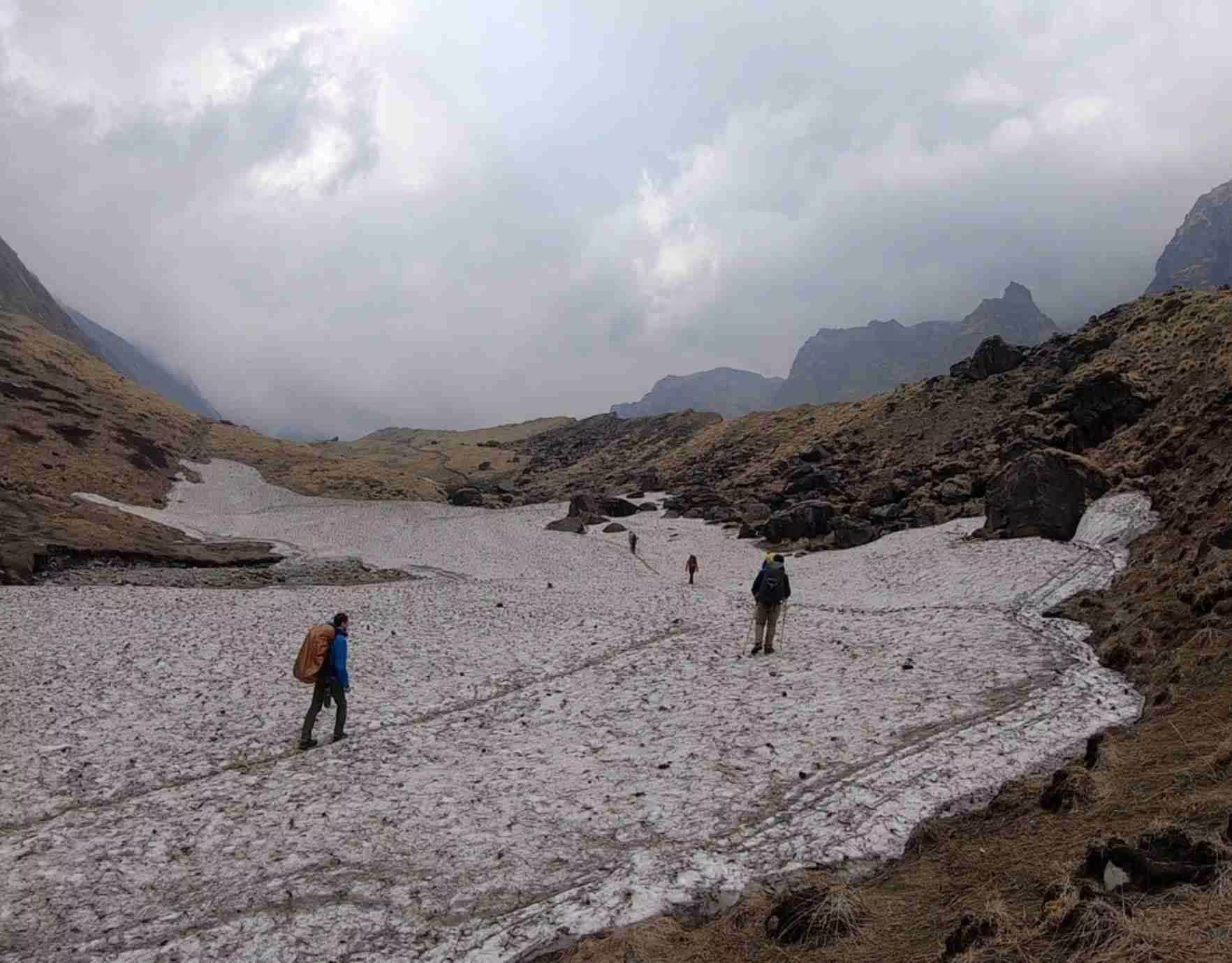
Most popular route ascends from Lakeside area requiring 2-3 hours steady climbing. Trail begins near Phewa Lake's northern shore following dirt roads and stone paths through terraced farmland and scattered villages. Initial gentle slopes gradually steepen requiring sustained effort. Regular tea shops provide rest opportunities and refreshments.
Early morning starts (5:00-6:00 AM) allow reaching summit for sunrise. Pre-dawn hiking requires headlamps though trails well-established reducing getting lost risks. Shared experience with other sunrise seekers creates camaraderie. Morning coolness makes uphill comfortable. After sunrise viewing, descent takes 1.5-2 hours arriving back in Lakeside by mid-morning leaving day free for other activities.
Afternoon hikes avoid crowds though missing optimal viewing light. However, sunset views compensate with different atmospheric conditions. Evening return requires careful timing ensuring adequate daylight though headlamps provide backup. Some hikers prefer afternoon-evening timing allowing sleeping late while still experiencing spectacular lighting.
Vehicle Road Access
Paved road allows vehicles reaching parking area approximately 50 meters below summit viewpoint. Five-minute walk on well-maintained stairs reaches observation deck. This option suits those with limited time, mobility concerns, or simply preferring convenience. Taxis from Lakeside charge NPR 1,500-2,000 ($12-16) round trip with waiting time.
Early morning taxi rides achieve sunrise timing without hiking effort. However, missing gradual scenery revelation and physical accomplishment diminishes experience somewhat. Combination approaches—hiking up, taxiing down—balance effort with convenience while ensuring energy for other activities. Understanding personal fitness and preferences guides choice.
Naudanda Extension Route
Extending beyond Sarangkot, trails continue to Naudanda village at 1,600 meters requiring additional 1-2 hours. This hillside settlement offers traditional village atmosphere and alternative mountain perspectives. Homestay options allow overnight stays experiencing rural life authenticity. Return options include continuing to Kande connecting with vehicle roads or retracing to Sarangkot.
Three-hour total hiking creates satisfying half-day adventure suitable for moderately fit trekkers. Village interactions provide cultural dimension beyond pure scenery appreciation. Understanding village economy, agriculture, and daily life enriches Nepal understanding beyond tourist highlights. Local tea shops serve simple meals supporting community economy.
Viewpoint Facilities and Features
Summit Observation Deck
Concrete platform with railings provides safe viewing area. Information boards identify visible peaks though accuracy varies. Telescopes (coin-operated) allow close-up mountain viewing though naked eye usually sufficient. Benches accommodate groups though seating limited during peak times. Arriving early secures prime positions for sunrise photography.
View Tower
Taller structure offers elevated perspectives above ground-level obstructions. Additional height reveals more distant peaks and expands valley views. However, entry sometimes closed for maintenance. When accessible, climbing provides marginal viewing improvements though ground deck usually adequate. Understanding tower availability prevents disappointment.
Tea Shops and Refreshments
Several small tea shops clustered near viewpoint serve hot drinks, snacks, and simple meals. Menu options include Nepali tea (chiya), coffee, instant noodles, omelets, and dal bhat. Prices higher than Pokhara due to hilltop location though still reasonable. Supporting these businesses maintains local economy while providing necessary services for visitors.
Restroom facilities basic but functional. Cleanliness varies so lowering expectations prevents disappointment. Bringing hand sanitizer recommended. Understanding remote location limitations encourages appreciation for available services rather than complaints about standards.
Adventure Activities from Sarangkot
Paragliding Launch Site
Sarangkot gained international recognition as premier paragliding destination. Consistent thermal currents, spectacular scenery, and relatively safe landing zones create ideal conditions. Professional operators maintain safety standards and equipment. Tandem flights with experienced pilots require no previous experience allowing anyone participating.
Typical flights last 30-45 minutes gliding over Pokhara Valley with Himalayan backdrop. Pilots perform gentle maneuvers or more aggressive aerobatics depending on passenger preference and conditions. GoPro cameras mounted on helmets capture footage for lasting memories. Landing occurs at lakeside fields after exhilarating descent.
Costs range NPR 6,000-10,000 ($48-80) depending on flight duration and season. October-November and March-May offer most reliable conditions. Morning flights usually best before afternoon winds strengthen. Booking through reputable operators ensures proper insurance and equipment maintenance. Understanding safety protocols and weather cancellation policies prevents disappointment.
Zipline Adventure
High-speed zipline launches from Sarangkot descending toward valley at thrilling velocity. Claiming title as world's steepest zipline (though disputed), the ride provides adrenaline rush for adventure seekers. Harnessed participants zip along cable suspended over terraced farmland and villages traveling approximately 1.8 kilometers descending 600 meters.
Costs approximately NPR 8,000-10,000 ($64-80) including transportation and safety equipment. Combined paragliding-zipline packages available offering both activities at reduced rates. Weight and health restrictions apply ensuring safety. Understanding limitations before planning prevents disappointment for those unable participating.
Wildlife Viewing Possibilities
Forested hillsides surrounding Sarangkot harbor wildlife including barking deer, wild boar, porcupines, and various bird species. Occasional leopard presence creates exotic possibility though actual sightings extremely rare. Morning and evening hours increase wildlife encounter chances. Maintaining quiet and watchfulness improves opportunities.
Tiger claims sometimes mentioned though no confirmed sightings in recent decades. Wild stories perhaps enhance adventure narrative though setting realistic expectations prevents disappointment. Appreciating smaller wildlife and bird diversity provides genuine nature experiences without requiring big cat encounters.
Best Times for Visiting Sarangkot
Seasonal Considerations
Autumn (September-November): Peak season with clearest mountain visibility. Post-monsoon atmosphere washed clean. Comfortable temperatures. Maximum tourist crowds especially weekends. Early booking recommended for paragliding.
Spring (March-May): Second-best season with good clarity and blooming rhododendrons at lower elevations. Temperatures warming though still comfortable. Pre-monsoon haze develops late May reducing visibility.
Winter (December-February): Crystal-clear visibility though cold mornings. Frost possible at summit requiring warm layers. Fewer tourists create peaceful atmosphere. Shorter days limit timing flexibility.
Monsoon (June-August): Cloud cover obscures mountains most days. However, occasional clear mornings provide stunning views. Lush green landscapes and dramatic cloud formations offer different aesthetic. Very few tourists. Significantly cheaper accommodation and services.
Daily Timing
Sunrise (5:30-6:30 AM depending on season): Most popular time with maximum crowds. Golden light illuminates peaks dramatically. Pre-dawn darkness requires headlamps or arriving by vehicle. Post-sunrise breakfast at tea shops creates pleasant social atmosphere.
Mid-Morning (8:00-10:00 AM): Crowds dispersing. Light losing golden quality though still clear. Comfortable temperatures. Good option for those unable early rising.
Afternoon (3:00-5:00 PM): Different lighting angles. Fewer tourists than morning. Sunset provides alternative spectacular lighting. Evening return requires timing daylight carefully.
Night: Some visit for stargazing though light pollution from Pokhara reduces clarity. Full moon nights create magical mountain silhouettes though detail invisible. Safety concerns navigating paths in darkness limit appeal.
Cultural Aspects and Village Life
Traditional Hill Villages
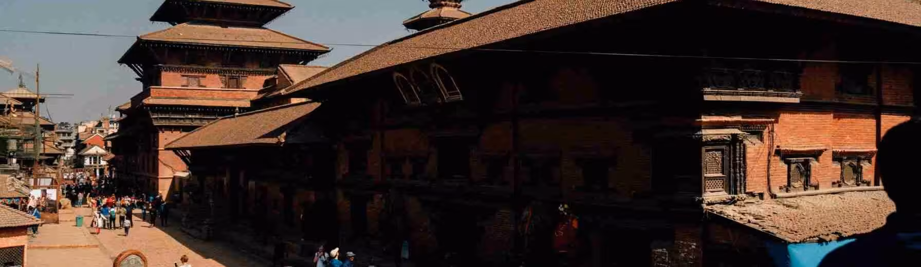
Routes to Sarangkot pass through traditional Gurung and Brahmin villages maintaining agricultural lifestyles. Stone houses with slate roofs cluster along hillsides. Terraced fields cascade down slopes growing rice, millet, vegetables, and maize. Water buffalo and goats graze near homes. Daily life continues around occasional tourist traffic.
Friendly interactions with villagers provide cultural insights. Elders sitting in sun observe passersby sometimes initiating conversations. Children walk to schools in clean uniforms. Women carry firewood or water. Men work fields or repair houses. Respectful observation and basic Nepali greetings create positive encounters.
Supporting Local Economy
Hiking rather than driving benefits local economy through tea shop patronage. Overnight stays in Naudanda homestays directly support families. Purchasing local products including honey, handicrafts, or vegetables provides fair-price income. Understanding economic challenges facing hill agriculture encourages supporting sustainable tourism approaches.
Practical Hiking Information
What to Bring
Comfortable hiking shoes with good grip, layered clothing for temperature changes, sun protection (hat, sunscreen, sunglasses), water bottles (2 liters recommended), energy snacks, camera with charged batteries, small first aid kit, headlamp for pre-dawn starts, cash for tea shops and entry fees, and trekking poles (optional but helpful).
Physical Preparation
Moderate fitness suffices though sustained uphill challenges sedentary individuals. Several days in Pokhara acclimatizing to elevation helps. Practice walks around lakeside prepare legs for climbing. Understanding personal limitations prevents overexertion. Numerous rest stops allow recovery as needed.
Safety Considerations
Well-established trails reduce getting lost risks though pre-dawn starts increase confusion potential. Staying on main paths prevents wandering. Local asking directions if uncertain. Cell phone coverage generally adequate allowing emergency communication. Travel insurance covering trekking activities recommended.
Monsoon rains create slippery conditions requiring extra caution. Leeches appear below 2,000 meters during wet season requiring tucked pants and repellent. Wildlife encounters extremely unlikely though maintaining awareness prevents issues. Understanding environmental hazards allows appropriate precautions.
Frequently Asked Questions
Can I drive to the viewpoint?
Yes, paved road reaches parking area 50 meters below summit. Five-minute walk on stairs reaches observation deck. Taxis from Lakeside cost NPR 1,500-2,000 round trip.
How difficult is the hike?
Moderate difficulty requiring 2-3 hours steady uphill walking. Sustained climbing challenges sedentary individuals though regular rest stops help. Reasonably fit hikers complete comfortably.
Is sunrise worth the early wake-up?
Absolutely. Golden light on peaks creates dramatic scenes impossible other times. Clear mornings most likely shortly after dawn. Shared experience with other sunrise seekers adds appeal.
Can I see Mount Everest from Sarangkot?
No, Everest lies too far east behind intervening ranges. However, Dhaulagiri, Annapurna, Manaslu, and 20+ other peaks exceeding 6,000 meters create overwhelming Himalayan panorama.
What about paragliding safety?
Professional operators maintain international safety standards. Thousands fly annually with minimal incidents. However, weather cancellations common prioritizing safety over profits. Choosing reputable operators ensures proper equipment and training.
Is Sarangkot suitable for children?
Vehicle access makes viewpoint accessible for all ages. Hiking route suitable for children 8+ with hiking experience. Carrying young children possible though sustained uphill challenging. Assessing individual child capabilities guides decision.

No comments yet. Be the first to share your thoughts!